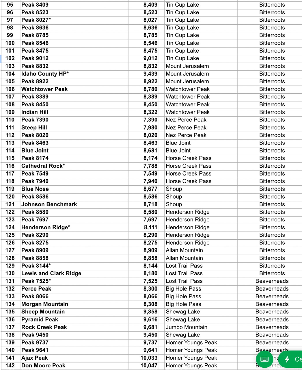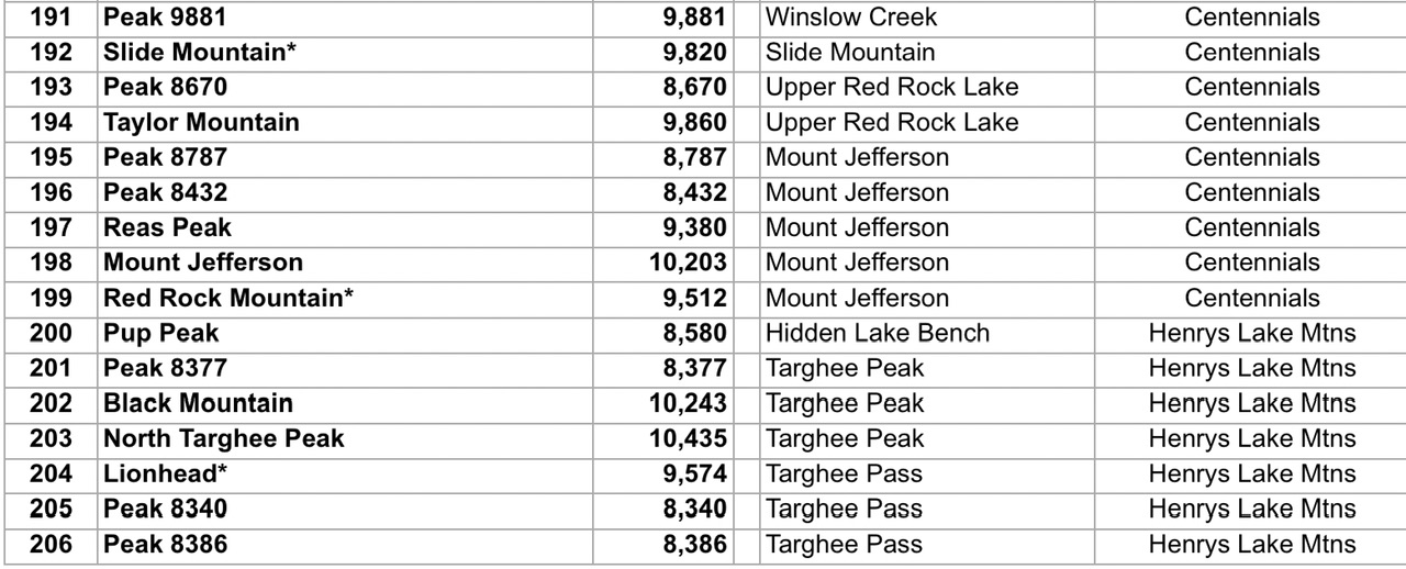
Idaho shares a lengthy border on its east side with both Montana and Wyoming. The ID/WY border begins east of Bear Lake at the extreme southeast corner of Idaho where the state shares a border with both Utah and Wyoming. From here, the ID/WY border heads in a straight line northward (on the longitudinal line 111 degrees WEST) all the way into Yellowstone National Park where it intersects the Continental Divide. At this point, the border becomes the dividing line between Idaho and Montana. The ID/MT border follows the Continental Divide northwest then west to a critical bend on the east side of the Birch Creek Valley near the Italian Peaks.
At this bend, the ID/MT border turns right-ish and heads northwest all the way to the Cabinet Mountains of northern Idaho, northeast of Coeur d’Alene. The border leaves the Continental Divide at Chief Joseph Pass. Upon crossing ID-200, the ID/MT border heads in a straight line northward (on the longitudinal line 116 degrees WEST) up through the Cabinet Mountains then the Purcell Mountains to reach the Canadian border. There are a total of 206 peaks that sit directly atop Idaho’s eastern border. None of the peaks lie on the ID/WY border. All of them are on the ID/MT border. Of the 206 peaks, 30 are unranked summits with many of those peaks named. There are quite a few peaks that are close to the border but are not included in this analysis. As with horseshoes and hand grenades, close does not count in this study.
My analysis relies on the LOJ database and uses the current LiDAR-updated elevation figures, so there will be elevation discrepancies with the book/website pages for some of the individual peaks. This study focuses on Idaho’s eastern border. Idaho’s southern border has only one border peak on the ID/UT border (Sheep Dip Mountain at 7,057 feet with 267 feet of prominence) and no border peaks on the ID/NV border. Idaho’s northern border with Canada has no border peaks. Idaho’s western border has no border peaks on either the ID/OR segment or the ID/WA segment. Much of Idaho’s western border is the Snake River.
From south to north, Idaho’s eastern border peaks cover five specific mountain ranges: Henrys Lake Mountains, Centennial Mountains, Beaverhead Mountains, Bitterroot Mountains, and the Purcell Mountains. The southernmost border peak is Peak 8386, just south of Targhee Pass. The northernmost peak is Line Point (6,673 feet), an unranked summit in the Purcell Mountains. There are 76 border peaks that reside on the Continental Divide.
Let’s drill down and look at the border peaks by regions (and mountain ranges), starting in the south. The border peaks begin just south of Targhee Pass with Peak 8386 in the Henrys Lake Mountains. The ID/MT border follows the Continental Divide from here for quite a long distance, all the way to Chief Joseph Pass. From Targhee Pass, the ID/MT border heads northwest up and around the north end of Henrys Lake, where the Continental Divide turns sharply southwest then south. There are only 7 border peaks in the Henrys Lake Mountains, 6 of which are ranked summits. The final peak is Pup Peak (8,580 feet). All of the border peaks in the Henrys Lake Mountains have individual pages on the IACG website.
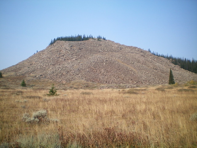
The east face of Pup Peak is a massive pile of loose boulders on a steep slope. Caution is advised here. Livingston Douglas Photo
The ID/MT border now enters the Centennial Mountains and heads west to Monida Pass at a crossing of I-15. There are 11 border peaks in the Centennials, 9 of which are ranked summits. The first peak is Red Rock Mountain (9,512 feet) and the final peak is Little Table Mountain (8,620 feet). From Monida Pass, the ID/MT border enters the Beaverhead Mountains and heads south then west then south to a sharp bend in the ridge in the Italian Peaks area. The border (which is still following the Continental Divide) heads northwest from this bend all the way to Chief Joseph Pass, north of Salmon. There are 58 border peaks in the Beaverhead Mountains, 6 of which are unranked summits. The first peak is Knoll (7,464 feet) and the final peak is Peak 7525. All of the border peaks of the Beaverhead Mountains have individual pages on the IACG website.
Little Table Mountain as viewed from across the Pete Creek Valley to the southeast. Livingston Douglas Photo
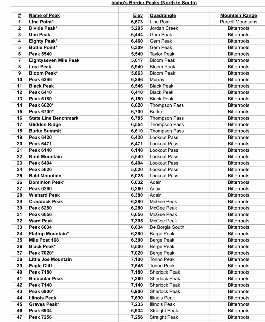
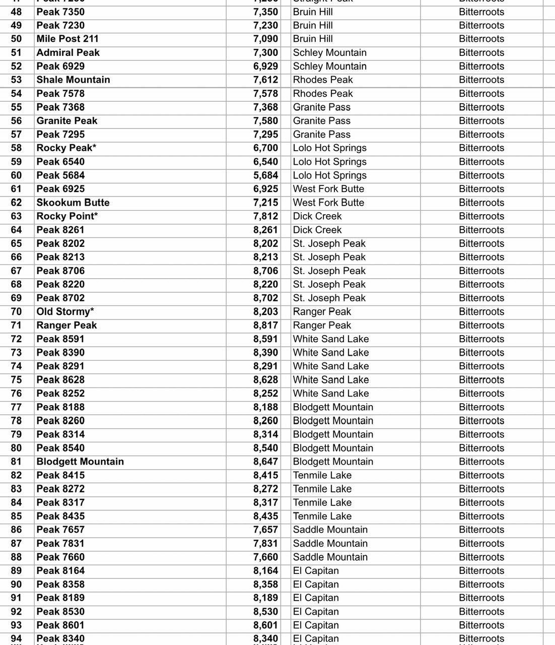
From Chief Joseph Pass, the ID/MT border leaves the Continental Divide and heads west to quickly cross Lost Trail Pass and enter the Bitterroot Mountains. The Bitterroots hold the majority of the border peaks at 129 total summits, 20 of which are unranked peaks. Many of these peaks are referred to in the Bitterroot Mountains overview, with specific peak listings under five subcategories. Please note that those peak listings focus on the Bitterroot CREST, not the ID/MT border. While there are extensive areas where the ID/MT border is on the Bitterroot Crest, it is not always the case. Consequently, there is a divergence between the border peaks of the Bitterroot Mountains and the peaks atop the Bitterroot Crest. They are NOT one and the same. There are also some peaks included on the Bitterroot Crest list that are not quite on the LOJ-designated ID/MT border and are not included in my list of border peaks.
From Chief Joseph Pass, the ID/MT border heads west for a few miles to reach Lost Trail Pass and a crossing of US-93. From Lost Trail Pass, the ID/MT border heads southwest then bends northwest and, finally, north to eventually reach Lolo Pass and a crossing of ID-12. From Lolo Pass, the ID/MT border goes northwest all the way to Lookout Pass and a crossing of I-90. From Lookout Pass, the ID/MT border heads north then northwest. After crossing Divide Peak (5,205 feet), it makes a final jog north to cross ID-200 near the hamlet of Cabinet, ID. This concludes the Bitterroot Mountains leg of the journey.
Once across ID-200, the ID/MT boundary heads straight northward through the Cabinet Mountains then the Purcell Mountains to reach the Canadian border. It does not follow a ridge crest, so there is only one border peak in this segment of the journey to Canada—Line Point (6,673 feet), an unranked summit. It sits in the Purcell Mountains. There are no border peaks in the Cabinet Mountains.
The border peaks include three of Idaho’s COHPs: Fremont County HP (North Targhee Peak at 10,435 feet), Shoshone County HP (Illinois Peak at 7,690 feet), and the Idaho County HP (9,439 feet). While the border peaks in the Henrys Lake Mountains and the Beaverhead Mountains are heavily climbed, many of the border peaks in the Bitterroot Mountains are unexplored or are rarely visited. The climbs are likely to be lengthy with a lot of unpleasant forest bushwhacking required. But for the avid Idaho mountain climber, there is the opportunity to stand atop some peaks that have never seen human visitation. Those who rely on a MC or ATV to get close to a summit need not apply.
