Elevation: 10,913 ft
Prominence: 670
Climbing and access information for this peak is on Page 268 of the book. The book lists the elevation at 10,925 feet. LiDAR measurements place the elevation at 10,913 feet. Livingston Douglas added a difficult traverse route from Straight Shot Peak. His route starts from the gentle, gravelly connecting saddle with Straight Shot Peak. Livingston notes that “descending from Straight Shot Peak involves a hard ridge traverse work but the ascent to Corner Shot isn’t a picnic either. Very loose, steep scree/gravel and many cliff bands.” Finally, I added Brett Sergenian’s photo of the upper route and his GPS track which starts from the Arentson Gulch and which shows the East Headwall Route set out in the book. Updated November 2024
Rick Baugher named this peak based on how it looks when viewed from US-93: tucked into the corner of the Pahsimeroi Range. Rick climbed the peak in 1994 and found no evidence of previous ascent after encountering a short, exposed Class 3 section near the top. USGS Grouse Creek Mountain
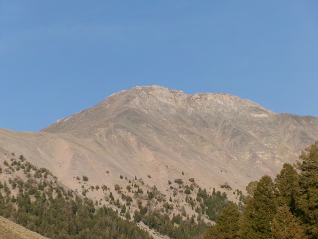
Corner Shot Peak as viewed from the southeast. Rick Baugher Photo
West Ridge (With North Ridge Finish) and North Ridge/Northwest Face by Livingston Douglas
The following narrative covers my traverse from Straight Shot Peak to Corner Shot Peak (10,913 feet). The entire climb of the two peaks covers 6.0 miles with 4,200 feet of elevation gain round trip.
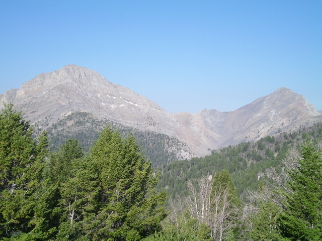
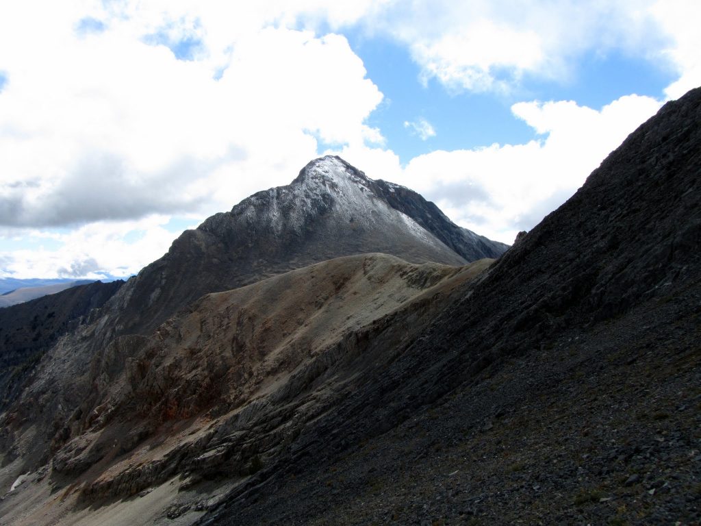
Straight Shot Peak (right) and Corner Shot Peak (left) as viewed from the east. Livingston Douglas Photo
Access
Arentson Gulch Road [(B)(4) on Page 292 of the Book]. Here are more specific driving details. From US-93 northwest of Mackay at virtual MM135.9, turn right/east onto [signed] Arentson Gulch Road. Reset your odometer here. At 0.4 miles, the road reaches an unsigned junction at a cattle fence/gate. Turn left/north here and go through the cattle gate. At 1.9 miles, go through a second cattle gate. At 3.4 miles, reach an unsigned road junction. A short spur road goes left.
Continue straight here on Arentson Gulch Road. The road turns to dirt and gets a bit rougher here. At 3.5 miles, reach the [signed] Challis National Forest boundary. At 3.6 miles, reach a fork in the road. Go right/northeast here onto a spur road that heads up into a side gulch. At 4.0 miles, reach a cattle cistern and a forested campsite. At 4.4 miles, reach an unsigned road junction and a fork in the gulch. Park here (7,815 feet and 44⁰15’00”N, 113⁰54’24”W).
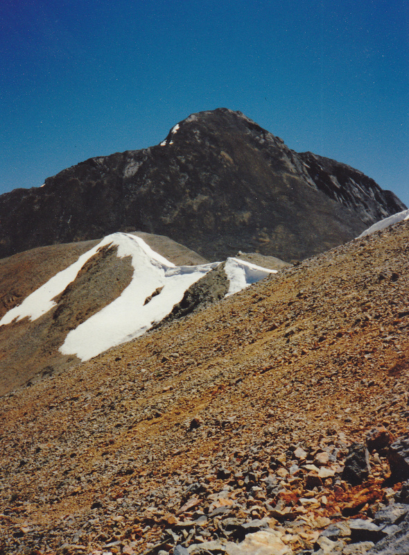
Corner Shot Peak (summit hump is left of center), its west ridge (left of center, coming at the camera), and its connecting ridge with Straight Shot Peak (well left of center). The west ridge was my ascent route. Livingston Douglas Photo
Map Errors and Website Corrections
The USGS map fails to show the full extent of the 2-track heading northeast then east up a side gulch and away from Arentson Gulch. This grassy, narrow 2-track continues about 0.4 miles from the cattle cistern (where the USGS topo map shows the road’s end) to an unsigned junction. It continues another 0.2 miles to its end in the forested, left fork of the side gulch.
Maps show Arentson Gulch Road as a 4WD road when, in fact, it is pretty smooth and decent (gravel base) 2-track road for its first 3.5 miles. LiDAR updates show Straight Shot Peak at 10,726 feet with a prominence of 534 feet. These figures differ from the book/website figures.
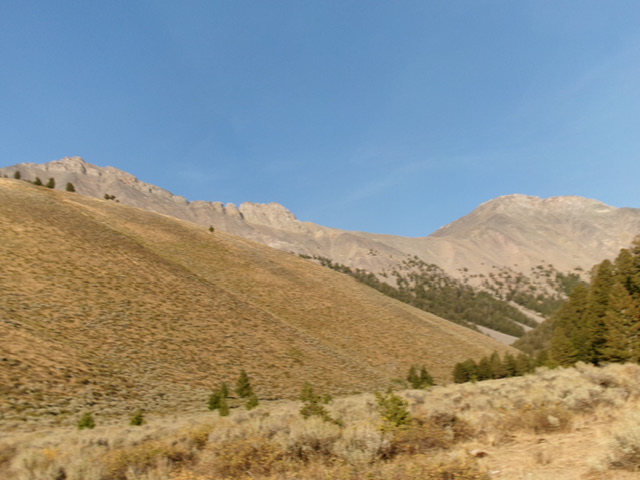
Straight Shot Peak (at far left) and Corner Shot Peak (at far right) as viewed from the valley floor to the west/southwest. Livingston Douglas Photo
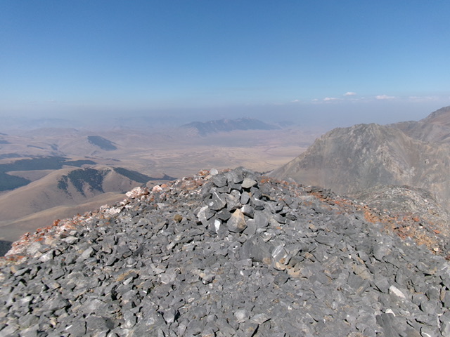
The cairned summit of Corner Shot Peak. Livingston Douglas Photo
West Ridge (With North Ridge Finish), Class 3+
The Climb
From the 9,900-foot connecting saddle with Straight Shot Peak (10,726 feet), scramble southeast up undulating gravel bars to reach steeper terrain on the crest of the [now better-defined] west ridge of Corner Shot Peak. Scramble up the loose scree/gravel on the west ridge, using firm ground rock, minor rocky outcrops, and goat trails to help gain some footing.
Stay on the right/south edge of the ridge crest as its sides are steep, loose, and tedious. The ridge is quite steep in spots but is never worse than Class 3. High up, the ridge merges with the north ridge. Head right/southeast along the rocky, choppy ridge crest on mostly Class 3 ridge rock. A short, knife-edged Class 3+ section must be crossed. From there, scramble up a final section of the rocky, narrow ridge to the cairned summit of Corner Shot Peak.
North Ridge/Northwest Face, Class 3+
The Descent
From the summit, descend the narrow, rocky north ridge and continue past its junction with the west ridge to reach the top of the steep-ish northwest face. This won’t be as easy as it looks from a distance or as easy as the Book implies that it is. Leave the ridge and descend loose, steep talus/scree on the massive face. This section is a bit tedious and requires much more downclimbing than boot-skiing, though there are a few patches of loose scree/gravel that can be boot-skiied. Lower down, find goat trails (and beds) and more scree/gravel to boot-ski on gentler angles and slopes. The final gravel bar descent to the 9,900-foot connecting saddle was fast and fun—boot-skiing all the way.
From the saddle, descend a shoulder that heads directly southwest down to the north fork of the critical gulch that will lead you back to the road fork and your parked vehicle. But there will be a surprising amount of work necessary to get there. Descend the steep-ish, open shoulder in scree/gravel (with a little boot-skiing) to reach tree line. [The better option is to leave the shoulder and descend into one of two magnificent gravel gullies on either side of the shoulder. From a distance, it looks like boot-ski heaven in either one of those gullies most, if not all, of the way down to the drainage below.]
Once below tree line, the shoulder becomes quite steep and gravelly. There are many areas to boot-ski down this semi-open terrain. A bit of bushwhacking near the bottom puts you into the narrow drainage. Surprisingly, this gulch is a surprisingly tedious, unpleasant bushwhack down to the old 2-track road. The drainage is dry and rocky, with plenty of brush and some deadfall too. Bash westward down through this mess to reach a cattle trail and then the old 2-track. Follow the old 2-track road for 0.2 miles down to the unsigned road junction at the fork in the gulch/canyon and your parked vehicle.
Corner Shot Peak as viewed from the saddle with Straight Shot Peak. George Reinier Photo
Brett Sergenian GPS Track and Photo
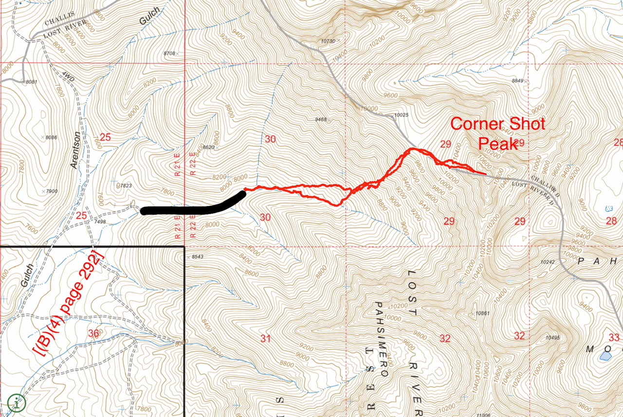
Brett Sergenian’s GPS track. The black line identifies the upper extension of the road which is not shown on the map. Roundtrip stats: 3.4 miles with 2,800 feet of elevation gain.
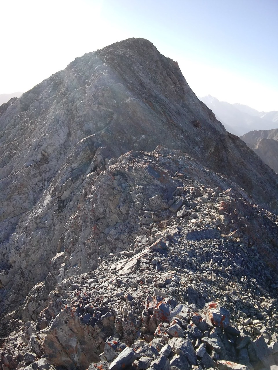
Above the east headwall. This is the final (Class 3) section of the route to the summit. Brett Sergenian Photo
Additional Resources
Regions: EASTERN IDAHO->Lost River Range->Pahsimeroi Range
Mountain Range: Lost River Range
First Ascent Information:
- First Ascent Year: 1994
- Season: Summer
- Route: East headwall.
- Party: Rick Baugher and Chuck Furguson
Longitude: -113.87759 Latitude: 44.25239