Elevation: 8,411 ft
Prominence: 871
Climbing and access information for this peak is on Page 212 of the book. Published February 2025
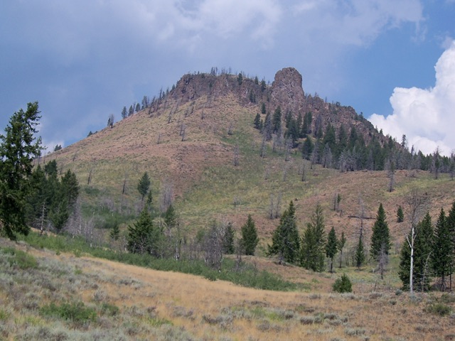
Griffin Butte is located just northwest of Ketchum on the west side of ID-75. It separates Adams Gulch from Fox Creek. The south side of the butte is snow-free by mid-Spring. While there is no trail to the summit, much of the climb can be done on trails that traverse the south side of the peak. USGS Griffin Butte
Griffin Butte. Rick Baugher Photo
Access
From Ketchum, drive 1.6 miles north on ID-75 to a signed turnoff for Adams Gulch Road. Go left/west onto Adams Gulch Road and drive across a bridge over the Big Wood River to reach a signed junction with Flowers Mill Road. Turn left here and continue about a mile to the large trailhead parking lot for the Adams Gulch Trail [(A)(6)(a) on Page 213] . Park here (5,980 feet).
Southeast Ridge, Class 2
The Climb
From the Adams Gulch trailhead, hike about ½ mile west up the Sunnyside Trail on the north side of Adams Gulch Creek. Leave the trail and bushwhack north then northeast up a scrub shoulder to reach a ridge point at 6,420 feet. This ridge point is the leftmost of two prominent ridge points that you can see from the trail. You are now on the southeast ridge. Follow the open ridge northwest and drop 150 vertical feet to a saddle. Continue northwest up to another ridge point at about 6,660 feet. Head northwest from this point along a narrow ridge section and drop 120 vertical feet to a second saddle.
From this saddle, scramble northwest to quickly reach a narrow north-south ridge section at 6,820 feet. Follow the ridge crest briefly north then drop a short distance to a third saddle. From here, scramble northwest to about 7,200 feet on the south face. You will cross the Adams Loop Trail en route. Head west across the south face to reach a southwest spur of the south ridge. Follow this shoulder northeast up to Point 8275 (the south summit). Continue north on the easy, but narrow, summit ridge to reach the high point of Griffin Butte at 8,441 feet.
South Face, Class 2
From the summit, return back to Point 8275. Descend the southwest spur then scramble south then southeast to intercept the Adams Loop Trail. Follow the trail east then south as it descends a gulch to reach the north side of Adams Gulch Creek. Continue east on the Sunnyside Trail back to the trailhead.
Additional Resources
Regions: Smoky Mountains->WESTERN IDAHO
Mountain Range: Smoky Mountains
Longitude: -114.4199 Latitude: 43.7296