Elevation: 4,611 ft
Prominence: 226

This butte is not in the book. Published November 2024
Hub Butte is located due south of the Twin Falls City/County Airport. This area is a mix of private and public land, so be careful. This climb is entirely on BLM land. USGS Hub Butte

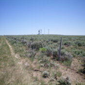
Hub Butte as viewed from midway up the 2-track road (and fence row) to the west-northwest. Livingston Douglas Photo
Access
From US-93 about 13 miles south of Twin Falls, turn east onto[signed] 3100N. Drive 3.8 miles east on paved 3100N to a signed junction with 2800E. Turn right/south onto 2800E and drive 1.0 mile to a fence row. Park along 2800E here (4,462 feet and 42⁰25’59”N, 114⁰29’55”W).
West Face, Class 2
The Climb
Most of this climb is Class 1. From 2800E, head east on the remnants of an old 2-track road that follows the north side of a fence row. Cross a cattle fence by the road and another about halfway up, where the old road is now much better. Continue east up the 2-track road to just northwest of the communication towers on the summit. Cross to the south side of the cattle fence and bushwhack southeast through an easy mix of short grass and gapped sagebrush to reach the multiple communication towers.
The USGS benchmark is in a concrete poured block just past the first communication tower and is the high point of Hub Butte. There is no summit cairn. This peak can only be reached via 3100N and 2800E. All of the other east-west roads are blocked by private land (or just don’t exist anymore). It is okay to hike on the Twin Falls Military Reservation land near the summit. That land is currently used for cattle grazing and is not fenced or posted.
Additional Resources

