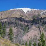
This peak is not in the book. Published March 2025 Dyer Mountain is a rugged, rocky hump on the east ridge of Lame Jake Peak (10,817 feet). It is most easily climbed in combination with Lame Jake Peak from the North Fork Pass Creek drainage. USGS Diamond Peak Access North Fork Pass Creek [(A)(2) on Page 313 of the book]. … Continue reading
Book Updates

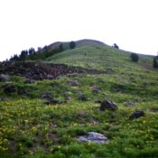
Climbing and access information for this peak is on Page 212 of the book. Published February 2025 Griffin Butte is located just northwest of Ketchum on the west side of ID-75. It separates Adams Gulch from Fox Creek. The south side of the butte is snow-free by mid-Spring. While there is no trail to the summit, much of the climb … Continue reading
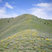
Climbing and access information for this peak is on Page 212 of the book. Published February 2025 Bear Peak is an impressive massif that separates Thompson Creek from Castle Creek in the Smoky Mountains. It is most easily reached from the south via Barr Gulch Road and Barr Gulch Trail. The south ridge is the cleanest route to the top. … Continue reading
This peak is not in the book. Published February 2025 Peak 8763 is a rather insignificant ridgeline hump that is overshadowed by Johnstone Peak (9,949 feet) to its northeast. Indeed, it is just a ridge hump (albeit a ranked one) on the long southwest ridge of Johnstone Peak. Peak 8763 is most easily climbed from the Parker Gulch Trail to … Continue reading
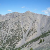
This peak is not in the book. Published February 2025 Triple Peaks is a beautiful ridgeline peak that towers over Trail Creek Road and is due north of the Boundary Campground. It is one of several ranked summits that are on a long ridge that separates Trail Creek from Lake Creek. Triple Peaks is most easily climbed via its south … Continue reading
This peak is not in the book. The elevation is based on LiDAR measurements. The map elevation is 10,601 feet. Published December 2024 Striped Peak is a rocky bump high on the east ridge of Shril Benchmark. It sits on a ridge corner where the south ridge of Shril Benchmark descends to the valley floor. USGS Eightmile Canyon Access Same … Continue reading