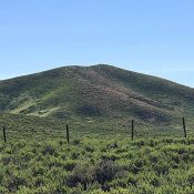
Peak 6270

Peak 6270 Viewed from the west.

This peak is not in the book. Published June 2019 Peak 6270 is located east of the Featherville Highway in the southwestern-most reaches of the Soldier Mountains. It anchors the west end of a long east/west trending ridge that rises up along the Western Camas Prairie. USGS High Prairie Access From the I-84/US-20 Exit, drive 31.9 miles on ID-20 to … Continue reading
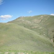
Appendicitis Hill by Livingston Douglas

Appendicitis Hill as viewed from the south. Livingston Douglas Photo

This peak is not in the book. Published June 2019 Appendicitis Hill is located northwest of Arco, Idaho in the easternmost lobe of the Pioneer Mountains. The origin of the name is based on famed USGS surveyor T.M. Bannon who suffered an attack of appendicitis while surveying the peak. USGS Appendicitis Hill Access From US-93 in Moore, ID, drive west … Continue reading

Shellrock Peak

Climbing and access information for this peak is on Page 122 of the peak. Published June 2019 Shellrock Peak is a former lookout site on the Johnson Creek/Middle Fork Divide. This is a remote location which will take several hard hiking days to reach. USGS Shellrock Peak Bing Young provided the following summary of the peak’s history as a lookout: … Continue reading

Two Point Peak

Climbing and access information for this peak is on Page 122 of the book. This peak was incorrectly identified in the book as Two Point “Mountain.” Published June 2019 Two Point Peak is located in the middle of the Frank Church River of No Return Wilderness south of Mormon Mountain and just south of Brush Creek Summit and FST-058. USGS … Continue reading

Stormy Peak

This peak is not in the book. Published June 2019 Stormy Peak is located 19 miles northwest of Salmon, Idaho and due south of the Salmon River. It has an active fire lookout which is on the National Historic Lookout Register. USGS Pine Creek Ridge Bing Young provided the following narrative: The Stormy Peak Lookout, along with Long Tom and … Continue reading

Red Mountain 6341

Red Mountain viewed from Peak 6499 (Mercury Peak)

This peak is not in the book. The best approach is from the east via the Bachman Grade Road. Paul Leclerc contributed the alternative, more difficult  northern access and route information for this remote, difficult-to-access peak. Updated October 2020 Red Mountain is an attractive peak located northeast of Quicksilver Mountain and the main Owyhee Mountains Crest. The summit is an excellent … Continue reading