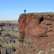
This peak is not in the book. This peak, unofficially named Montini Volcano, is located on the South Rim of the Snake River Canyon in Owyhee County. It is the 50th-steepest peak in Idaho and the steepest peak in Owyhee County. USGS Sinker Butte Dan Robbins researched the history and approach to this out-of-the-way summit. Dan states: “Peak 2887 had … Continue reading
Book Updates
This peak is not in the book. There are two routes set out below. Updated November 2019 Peak 5444 is located at the east end of the Danskin Mountains. The peak’s high point is located on the west end on a long east-to-west ridge line. The summit is north of the Tollgate Historical Marker on US-20. The peak can be … Continue reading
This peak and North Frenchman Peak (which is also discussed herein) are not in the book. Dave Pahlas and John Platt provided the information for the winter ascent of both peaks which is set out below. Livingston Douglas authored the Livingston Douglas North Ridge/South Ridge Traverse entry below. Updated November 2022 Frenchman Peak and North Frenchman Peak (9,139 feet) are located … Continue reading
This peak is not in the book. Bull Horn Mountain is located northeast of Bull Trout Point and due east of ID-21 and the northernmost Sawtooth peak, Copper Mountain. It is relatively quick ascent from the highway. Park in the large pullout on the west side of ID-21 at Newman Creek in the Summer or at the point where the … Continue reading
Climbing and access information for this peak is on Page 311 of the book. Livingston Douglas provided the new route updates set out below. Updated December 2019 Mount Hoopes is located just south of Tyler Peak. Although it is one of the most impressive of the southern Lemhi Range peaks, Mount Hoopes is seldom climbed. In December 2015, Larry Prescott … Continue reading
Climbing and access information for this peak is on Page 360 of the book. South Putnam is located north of Mount Bonneville. USGS South Putnam Mountain Ken Jones provided the following update Ascent Trip Report I hoped to drive to 7,080 feet, but the road is closed at about the “24” in Section 24 on the map. It is washed … Continue reading