Elevation: 11,100 ft
Prominence: 280
This peak is not in the book. Published November 2024
Peak 11100 is a rugged, rocky summit that is located on the high ridgeline that includes Atlas Peak (11,020 feet) to the northwest and Alcyone Peak (11,261 feet) to the southeast. It is a fun, Class 3 scramble from Green Lake to its southwest. USGS Smiley Mountain
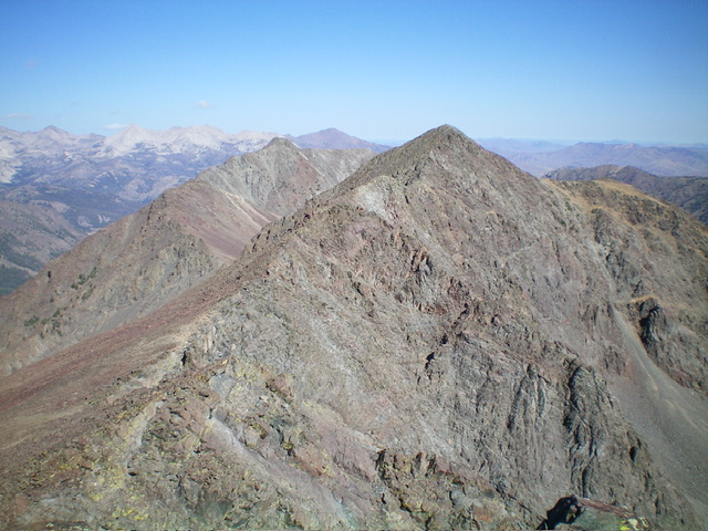
Peak 11100 (summit hump is right of center) and its rugged south ridge (left of center and center). The south ridge was my ascent route. Livingston Douglas Photo
Access
Muldoon Canyon Road [(C)(3.4) on Page 260 of the Book]. Drive 3.0 miles south on Muldoon Canyon Road to a signed junction with the Green Lake 4WD Road/FSR-511. Drive 0.1 miles east up Green Lake Road and park in a pullout before the road steepens and becomes much rockier. This pullout is at 8,120 feet and 43⁰42’39”N, 113⁰53’24”W.
This is the first leg of a 2-peak adventure that includes Peak 11100 and Peak 11120. It covers 9.0 miles with 3,800 feet of elevation gain round trip. If you can navigate the rugged Green Lake Road all the way to the Green Lake Trailhead (9,320 feet), you can shorten the climb by about 4.0 miles and reduce the elevation gain by about 1,200 feet round trip.
Map Errors
The Green Lake 4WD Road ends at the Green Lake Trailhead. The USGS topo map incorrectly shows the road continuing south to an old mine. That segment of the road no longer exists. The USGS topo map fails to show the Green Lake Trail. There are actually two trails to Green Lake—one on the north side of the outlet stream and one on the south side of the outlet stream. Each has a steep section of uphill before reaching Green Lake at its west end.
West Spur/South Ridge, Class 3
The Climb
From the parking pullout, hike about two miles up steep, sometimes-rocky Green Lake Road to its end at the Green Lake Trailhead (9,320 feet). Hike east up the steep Green Lake Trail for about ½ mile to the west end of Green Lake at the head of the outlet stream. From the outlet stream, follow a use trail northeast then east to the north side of the beautiful lake. Leave the trail and scramble up a dry gully that heads left/north up past a prominent rocky outcrop on its right/east side. Stay on the left side of this gully for the least-brushy bushwhack.
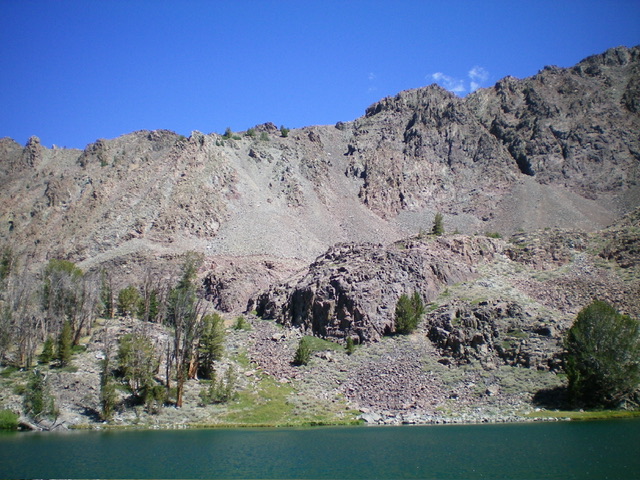
The south gully of the west spur of Peak 11100 as viewed from Green Lake. My ascent line is just left of center and heads up a talus/scree slope to the ridgeline. The rugged west spur is the skyline. Livingston Douglas Photo
The gully quickly leads up to a talus basin with a small patch of grass in its center. Stay to the left/west of the basin and scramble up a talus shoulder that heads north-northeast up to the crest of the west spur. Higher up, the shoulder ends and becomes a steep-ish face/gully of loose scree/gravel and minor rock ribs. The rocky ribs provide better footing in the climb up onto the west spur. Scramble north up this final section of misery to reach a few scattered pines near the ridge crest. Once on the west spur, begin a tedious slog eastward up more endless talus.
As you gain elevation, the west spur becomes rounded and eventually turns into more of a face before reaching the crest of the south ridge. High up, angle left/northeast to intercept the choppy, rocky south ridge. The south ridge is a narrow mess of ridge outcrops and towers with angled talus/scree on its left/west side. The right/east side of the ridge is steep, exposed face rock and aretes that must be avoided at all costs. Skirt past the ridge towers and try to minimize the ups and downs of this choppy ridge. Unfortunately, you must deal with angled, loose talus/scree and several arete crossings. Reach the final ridge saddle/notch. From there, climb north then northwest up endless steep-ish ridge rock and chutes of loose scree to reach the surprisingly gentle summit of Peak 11100. The summit has a decent cairn that is visible from a distance.
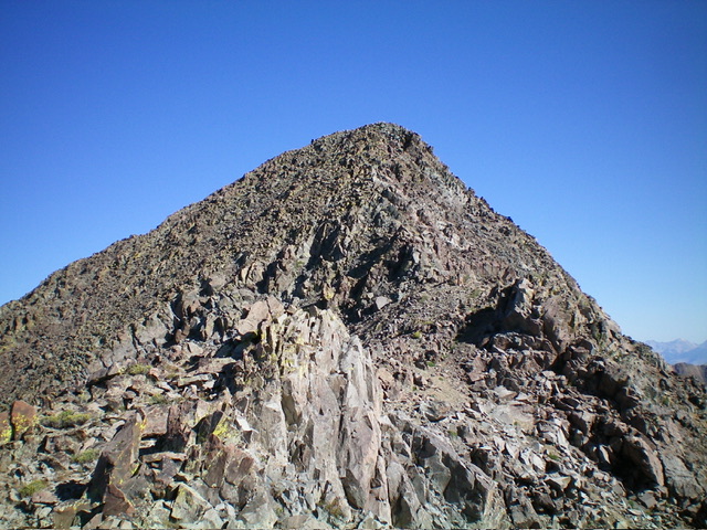
The rocky summit hump of Peak 11100 as viewed from high on the south ridge. Livingston Douglas Photo
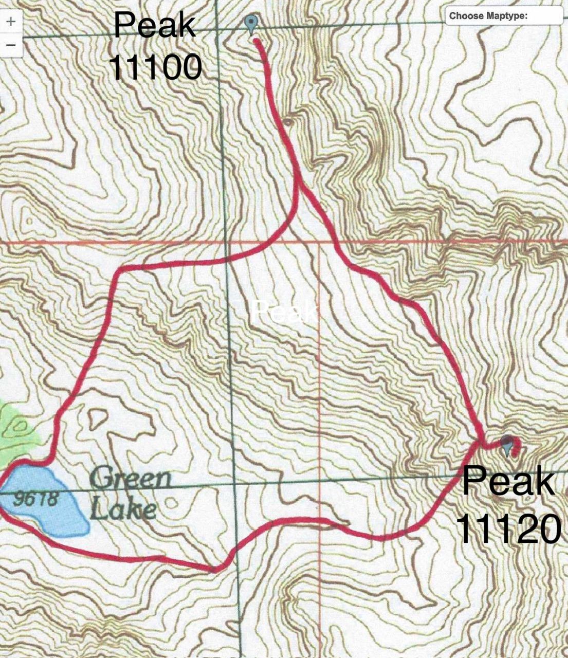
The red line on the left is the ascent route from Green Lake to Peak 11100. The red line in center and right of center is the descent route of Peak 11100 and connecting ridge to Peak 11120.
South Ridge Full, Class 3
The Descent
From the summit, return south-southeast on or just right/west of the ridge crest to reach the top of the west spur. From there, scramble southeast then east to the top dual-humped Point 11040+. From this rocky ridge point, descend south-southeast along a narrow, rocky ridge crest to the 10,820-foot connecting saddle with Peak 11120. The USGS topo map makes this ridge section look relatively straightforward, but it is not so. This ridge section is brutal. It is a series of wicked ridge towers with little relief on either side of the ridge. Impossible gaps between the towers. Very tedious Class 3 work.
Downclimb the left/east side of a few ridge towers on loose, unstable rock. Stay close to the ridge crest for the easiest going because the rock (and aretes) are even worse lower down. While descending this ridge section, get a good look at Peak 11120. It is clear that the north face of it is its weakness. But how to get onto the north face. THAT is the $64,000 question. The 10,820-foot ridge notch/saddle sits at the head of a rocky gully that leads nicely southwest then west down to Green Lake, a pleasant surprise. This notch concludes the first leg of today’s 2-peak journey. Peak 11120 is up next.
Additional Resources
Regions: EASTERN IDAHO->Pioneer Mountains
Mountain Range: Pioneer Mountains
Longitude: -113.8549 Latitude: 43.7151