Elevation: 11,120 ft
Prominence: 284
This peak is not in the book. Published November 2024
Peak 11120 is a very rugged, rocky summit that is located on the high ridgeline that includes Atlas Peak (11,020 feet) to the northwest and Alcyone Peak (11,261 feet) to the southeast. It is most easily climbed from a gully at the southeast end of Green Lake up to a ridge notch on its northwest side. While LOJ rates this peak as a Class 5.2 climb, I found a route that goes at Class 4. USGS Smiley Mountain

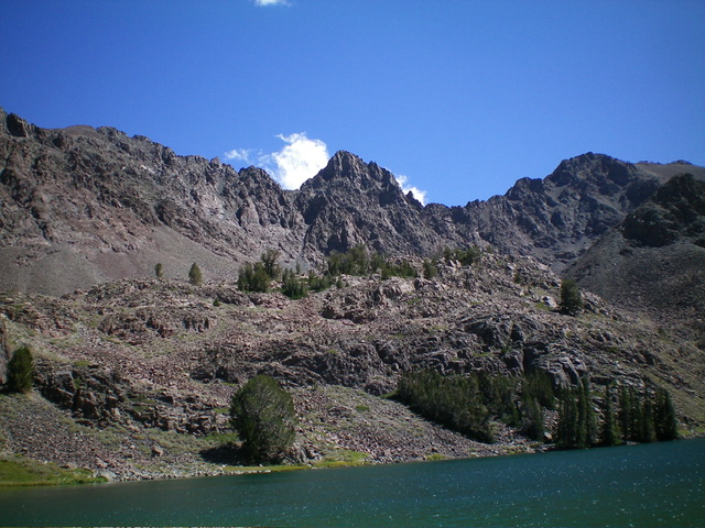
Peak 11120 (dead center) as viewed from the outlet of Green Lake to its west. Livingston Douglas Photo
Access
Same as for Peak 11100. This is the second leg of a 2-peak adventure that includes Peak 11100 and Peak 11120. It covers 9.0 miles with 3,800 feet of elevation gain round trip. If you can navigate the rugged Green Lake Road all the way to the Green Lake Trailhead (9,320 feet), you can shorten the climb by about 4.0 miles and reduce the elevation gain by about 1,200 feet round trip.
Map Errors
The Green Lake 4WD Road ends at the Green Lake Trailhead. The USGS topo map incorrectly shows the road continuing south to an old mine. That segment of the road no longer exists. The USGS topo map fails to show the Green Lake Trail. There are actually two trails to Green Lake—one on the north side of the outlet stream and one on the south side of the outlet stream. Each has a steep section of uphill before reaching Green Lake at its west end.
Northwest Ridge/North Face, Class 4
The Climb
From the 10,820-foot connecting ridge notch with Peak 11100, descend a ramp leading southeast on the west face of Peak 11120 to reach the bottom of a large gully that heads left/northeast up the face. The gully/chute is blocked by an arete. Climb left/north and cross this steep, narrow arete to reach a talus/scree gully that looks promising. Scramble right-ish/northeast up this gully (Class 2+ or Class 3) until it jogs left/north to head up to the crest of the northwest ridge at a point that is just below and west of the massive block on the summit ridge crest.
Once on the crest of the steep northwest ridge, climb it a short distance on narrow but solid rock. Reach a series of impossibly steep aretes and ridge towers. Your strategy now is “go left and up.” This will skirt these impossible aretes/towers and get you onto the easier north face. Leave the northwest ridge and traverse across steep face rock and climb up a chute or arete. Continue this routine until you reach the relatively easy face rock on the north face. You may get dead-ended by an arete/chute or two and have to downclimb to traverse farther over to find a climb-able one. Just keep going. This is full-on Class 4 work.
Once you reach the easier north face, it is a clear shot to the summit perch on a mix of Class 2-3 face rock, aretes, and chutes. I came up right onto the rocky, airy high point (lucky me!). There was a very small cairn atop the highest boulder. This is clearly the high point. The summit provides a stunning view of the Muldoon Creek drainage and of nearby Alcyone Peak to the southeast.

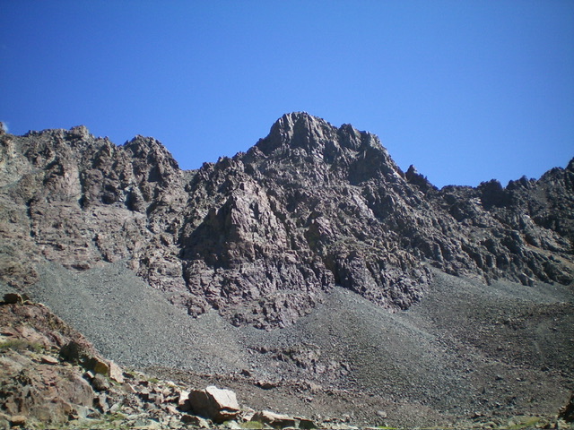
Peak 11120 as viewed from the west, just above Green Lake. My descent route is the rocky gully just left of center. Livingston Douglas Photo

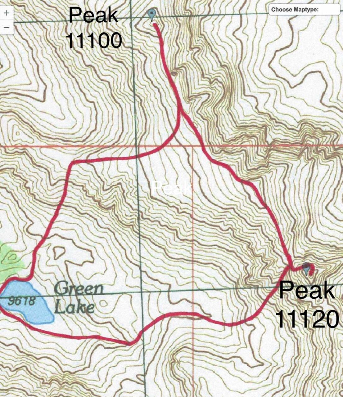
The ascent route for Peak 11120 is the red line coming up from the ridge notch just northwest of the peak. The descent route back to Green Lake is the red line in the lower half of the map.
North Face/Northwest Ridge/Southwest Gully, Class 4
The Descent
From the summit, descend the Northwest Ridge/North Face Route back to the base of the ramp on the west face. From there, descend into a prominent gully (the southwest gully) that comes down from the nearby ridge notch from which this climb began. The gully is a steep mess of loose talus (mostly) with some areas of scree and gravel. Descend it slowly and with great care. The gully heads down to a flatter area of more talus then jogs right/west to drop to a wide, prominent rocky gully/drainage that leads west to the southeast corner of Green Lake.
This wide gully is primarily large boulders with some talus mixed in. It is a bit tedious but it is not steep. The boulders are solid, so the downward scramble goes quickly. Once you reach Green Lake, follow a use trail on the left/south side of the small lake to return to the outlet stream. Follow the Green Lake Trail back down to the trailhead. Hike down the Green Lake Road to your parked vehicle.
Additional Resources
Regions: EASTERN IDAHO->Pioneer Mountains
Mountain Range: Pioneer Mountains
First Ascent Information:
- First Ascent Year: 2008
- Season: Summer
- Route: West Face
- Party: Pat McGrane
Longitude: -113.84796 Latitude: 43.70676
