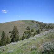
Elevation: 6,220 ft
Prominence: 320

This peak is not in the book. Published November 2024
Peak 6220 is a minor hump that separates Dairy Canyon from Houtz Canyon in the Sublett Range of southern Idaho. It is most easily climbed from a 2-track road to its south. USGS Badger Peak
Access
From ID-37 in Rockland, reset your odometer and drive west on [signed] Center Street (which soon becomes Houtz Canyon Road). At 2.9 miles, reach a signed junction with Miller Road (right). Continue straight on Houtz Canyon Road. At 5.6 miles, reach a signed junction with Dairy Canyon Road (right). Continue straight on Houtz Canyon Road. At 5.7 miles, reach the BLM boundary. Houtz Canyon Road now becomes [signed] BLM-660. At 8.8 miles, reach an unsigned road junction. Park in the grass just past this junction (5,545 feet and 42⁰30’15”N, 113⁰00’15”W).
South Ridge, Class 2
The Climb
From the road junction, hike west up an unnamed 2-track side road for about ¼ mile to just past a dry gully. Leave the road and scramble northwest up a steep slope of short grass/scrub to reach thicker, gapped scrub. Bushwhack up to the crest of the south ridge. Once on the ridge, head right-ish/north in open scrub (not too bad), drop 20 vertical feet to a minor saddle, then continue north then east to an elongated ridge hump. Bushwhack northeast to a saddle (40-foot drop). The sooner you descend to the saddle, the easier the scrub will be. From the saddle, scramble northwest in gapped grass/scrub then right/northeast to reach the bare summit area. This is clearly the high point of Peak 6220.
Additional Resources
Regions: SOUTHERN IDAHO->Sublett Range
Mountain Range: Sublett Range
Longitude: -113.0069 Latitude: 42.5131


