Elevation: 7,024 ft
Prominence: 799
This peak is not in the book. Updated November 2024
Peak 7024 is the high point of the Soda Springs Hills but only by seven feet over Peak 7017. It sits southeast of Tenmile Pass and northeast of Long Ridge. This area is a mix of private and public land, so be careful. Peak 7024 can only be reached on public land from the west via Tenmile Pass Cutoff Road. USGS Alexander
Access
The public access to Peak 7024 is from the [signed] Tenmile Pass Cutoff Road. This road can be reached either from Tenmile Pass Road to its north or from Ivins Road to its south. Please note that the Baugher route is closed to the public. His access road to the south side of Peak 7024 is now a posted, private ranch road. That route is not an option. The east side of Peak 7024 (which provides the shortest route to the summit) is also blocked by private ranch land. Access from Tenmile Pass (via Peak 6858) is blocked by a private ranch.
Access from the North
From US-30 east of Lava Hot Springs (at virtual MM378.5), drive up the [paved] Lund Highway to Bancroft. Leave the highway at Bancroft and head north up [paved] Chesterfield Road for 1-2 miles to a signed junction with Tenmile Pass Road. Turn right/east onto Tenmile Pass Road and drive up to a phosphate mining operation on the left/northwest side of the road. Continue another 0.4 miles northeast to reach a signed junction with Tenmile Pass Cutoff Road. This junction is about ½ mile before Tenmile Pass. Tenmile Pass Road is a well-maintained county road. Turn right/south onto Tenmile Pass Cutoff Road (a maintained county road but not as smooth as Tenmile Pass Road) and drive a short distance to the BLM public access points for a climb of Peak 7024.
Access from the South
From US-30 about two miles west of the US-30/ID-34 junction, turn north onto [signed] Ivins Road. Drive north on Ivins Road for about 3.5 miles to a signed junction with Cornelison Road. Cornelison Road is a maintained county road that heads east to the mouth of Swenson Valley/Canyon. Continue north on Ivins Road for about ½ mile to a sharp left/west bend in the road. Ivins Road heads west for about 0.3 mile to sharp bend right/north. The road then continues north for about a mile to another sharp left/west bend. There is a private ranch road that heads right-ish/northeast from here to reach the south side of Peak 7024. This is the Baugher route. But this road is now posted and is closed to public access.
Continue west on Ivins Road for about 0.5 miles to another sharp right/north bend. Head north for almost a mile to another sharp left/west bend in the road. Shortly after this bend, there is a signed junction with the Tenmile Pass Cutoff Road. Turn right/north onto the Cutoff Road (a maintained county road but not as smooth as Ivins Road or Tenmile Pass Road) and drive north-northeast to the BLM public access points for a climb of Peak 7024.
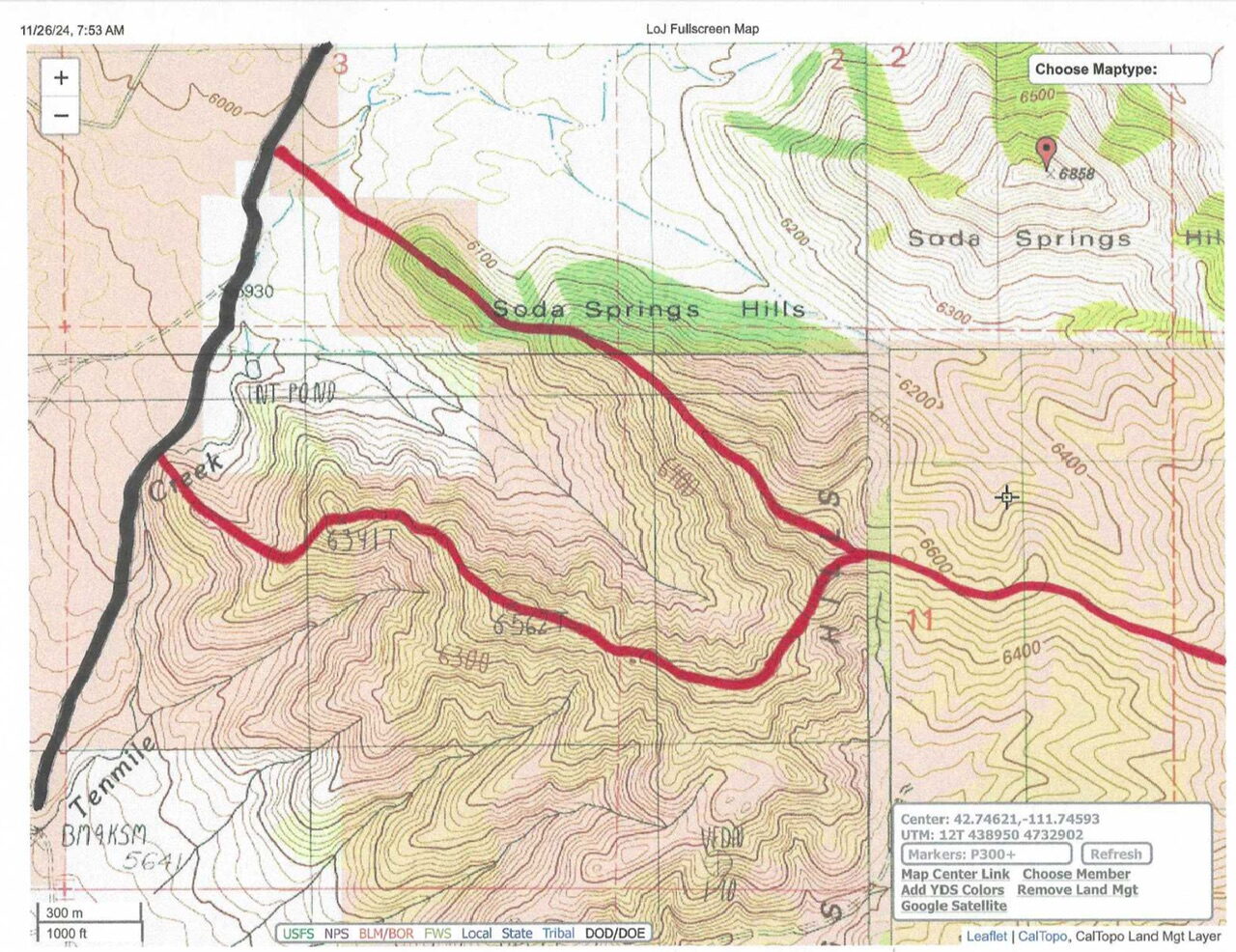
Public Access Points on Tenmile Pass Cutoff Road for West Ridge Climbing Routes, Class 2-3
There are two spots along the Tenmile Pass Cutoff Road that provide public access to the west side of Peak 7024 via BLM land (see map). The Cutoff Road is shown in black. The climbing routes are shown in red. The northern access point allows you to cross a gully then jump a BLM fence corner (which, by the way, is not condoned by BLM) to stay on BLM land. This route then climbs a spur ridge southeast up to the main west ridge of Peak 7024. Continue east on the ridge to the top. The summit of Peak 7024 appears to be on the border of BLM land and private land.
The southern access point is a short distance farther south on the Tenmile Pass Cutoff Road, where the road skirts past the base of a ridge to the east of the road. Leave the road here and climb the ridge southeast then northeast up to Point 6341. Continue east then southeast on the ridge up to Point 6562. From there, head east then northeast to reach the main west ridge of Peak 7024. Continue east up the west ridge to the summit. This hike is entirely on BLM land and does not require jumping a BLM fence corner.
Additional Resources
Regions: Blackfoot Mountains->Soda Springs Hills->SOUTHERN IDAHO
Mountain Range: Blackfoot Mountains
Longitude: -111.73501 Latitude: 42.74149
