Elevation: 7,208 ft
Prominence: 428
This peak is not in the book. Published December 2024
Peak 7208 is the highest foothill on the west side of Oxford Mountain (9,300 feet). It is located south of New Canyon and sits above the headwaters of Rattlesnake Creek. Peak 7208 is most easily climbed via its northeast side from the New Canyon ATV Trail/FST-222. USGS Malad Summit
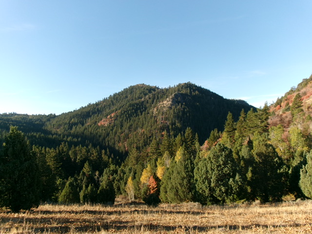
Peak 7208 as viewed from the northeast. Livingston Douglas Photo
Access
Same as for Peak 6940. This is the second leg of a 2-peak adventure that includes Peak 6940 and Peak 7208. It covers 6.5 miles with 2,350 feet of elevation gain round trip.
Map Errors and Other Corrections
The end of New Canyon Road (and the trailhead) is about ½ mile and 400 feet lower than the National Forest map (and Baugher) indicate. New Canyon Road/FSR-222 is a well-maintained county road to the National Forest boundary and a decent 2-track road above that point. It is not a 4WD road as maps indicate, though it has some minor rutting and a rocky patch just below the road’s end. The USGS topo map fails to show the full extent of FST-420. This ATV trail continues south up over a ridge crest (and beyond), well beyond the pond at 6,400 feet. This trail is very useful in getting close to Peak 7208.
Southeast Ridge, Class 2
The Climb
From the junction of FST-222 and FST-420 at the headwaters of New Canyon, follow FST-420 south for about two miles as it weaves its way to a ridge saddle just east of Point 6902 at about 6,840 feet. Another climber’s report incorrectly states that FST-420 goes to a ridge saddle west of Point 6902 at 6,780 feet. From the ridge saddle, leave FST-420 and follow a good cattle trail (initially) on the right/north side of a fence row up over Point 6902 and down to a saddle at 6,780 feet. The fence row does not go to the saddle so move away from it.
From this saddle, bushwhack through thick pines and maples west then northwest. Skirt a forested hump on its north side and reach a final ridge saddle at 6,820 feet in open terrain. Scramble north up the ridge in a mix of grass/scrub and scattered mountain mahogany. Drop to a final, minor ridge notch. From there, scramble northwest up steeper, looser scrub and gravel to reach a ridge corner and the official high point of Peak 7208. There is no summit cairn here.
The high summit ridgeline heading southwest appears to go slightly higher than this ridge corner. I investigated it and found a cairned hump about 100 feet to the southwest of the ridge corner. This hump seems to be at least as high as the ridge corner, perhaps a little higher than the official/northeast summit. Stand atop both points “just to be sure.”
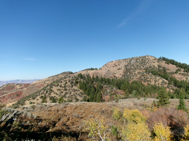
Peak 7208 (summit is right of center) and its southeast ridge (skyline left of center). This was my ascent route. Livingston Douglas Photo
Northeast Ridge, Class 3
The Descent
From the official/northeast summit, descend north then northeast down the steep, thick, sometimes-rocky, ridge to the valley floor. The northeast ridge is easy and flat at times. It also has at least two or three large ridge buttresses to downclimb (Class 3) or skirt the right/east side of. The ridge has areas of dense forest and thick brush, especially lower down. Loose scree and gravel is everywhere, even in the grass/scrub, so the ridge requires careful, patient downclimbing. Upon reaching the valley floor, follow a cattle trail briefly downstream alongside New Canyon Creek. Cross the small stream and scramble right/north a short distance up to reach FST-222. Follow FST-222 for about 0.2 miles down to the trailhead.
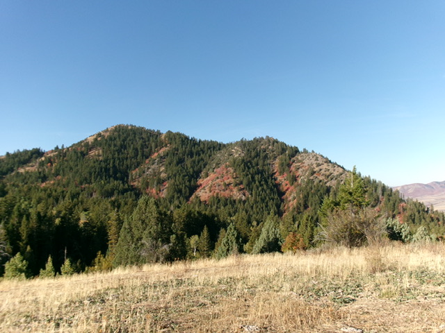
Peak 7208 (summit is left of center) and its rugged, steep northeast ridge (skyline right of center). This was my descent route. Livingston Douglas Photo
Additional Resources
Regions: Bannock Range->SOUTHERN IDAHO
Mountain Range: Bannock Range
First Ascent Information:
- Other First Ascent: Northeast Ridge—Descent
- Year: 2024
- Season: Summer
- Party: Livingston Douglas
Longitude: -112.1428 Latitude: 42.2739