Elevation: 7,241 ft
Prominence: 781
This peak is not in the book. Rick Baugher suggested the name because the Paul Benchmark is located just north of the summit. See Rick’s trip report linked below. Published November 2023
Peak 7241 sits on a north-south ridgeline on the east side of Arbon Valley in southern Idaho. It is most easily climbed from Knox Canyon Road East. Its west ridge is the most direct route to the summit. USGS Bradley Mountain
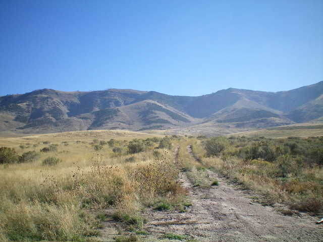
Peak 7241 (just left of center) and Point 7098 (just right of center) as viewed from the west (start of hike). Livingston Douglas Photo
Access
From Exit 52/Arbon Valley on I-86, drive south on [paved] Arbon Valley Road. At 23.5 miles, reach a signed junction with South Mink Creek Road. At 26.7 miles, reach a signed junction with Knox Canyon Road. Turn left/east onto Knox Canyon Road East. Reset your odometer here. At 1.9 miles, go left/northeast at an unsigned road junction. At 2.2 miles, park at an unsigned road junction. A weak 2-track road heads right/east from here (5,342 feet; 42⁰31’12”N, 112⁰30’46”W).
Map Errors
Knox Canyon Road East is a well-graded county road all the way to the 5,342-foot road junction. The USGS topo map shows it as a 4WD road after the first ½ mile but that is not accurate. The USGS topo map fails to show the 2-track road that heads right/south from the 5,267-foot bend in the road at the 1.9-mile point.
West Ridge, Class 2
The Climb
From the unsigned road junction, hike east up the overgrown, 2-track mining road to reach the base of two shoulders at a prominent gully that cuts the west face of Peak 7241. You have two options here. First, you can angle left-ish across the gully to reach the base of the west ridge. Second, you can continue up the old 2-track as it switchbacks its way into the prominent gully and scramble left/north up onto the west ridge in open terrain, reaching the west ridge above the partially-forested terrain on its lower half. The lower half of the west ridge is NOT mostly forested as the USGS topo map suggests.
If you choose the former option, scramble east then northeast up through open scrub with two patches of junipers to work through. If you choose the latter option, leave the overgrown 2-track and cross a dry gully through scrub and dead junipers. Once across the gully, scramble north up through a mix of scattered, dead junipers and scrub/grass to reach the west ridge just above the final patch of junipers. At this point, both routes follow the west ridge to the summit. From this juncture, head east up the open scrub on the ridge crest to reach a thick juniper forest high up. Worse yet, there is an ominous series of cliff bands above you to navigate. Head right/south to skirt beneath the steep cliff bands and climb up on them with relative ease.
A game trail will assist you in this diagonal upward ascent. Once above the troublesome area of thick junipers and cliff bands, bushwhack up through a juniper/pine forest to reach open terrain at about 7,100 feet. At this point, the west ridge merges into the south ridge. Follow the south ridge left/north in easy, open scrub to reach the summit of Peak 7241. The summit has an east-west fence row that turns north. There was no summit cairn so I built one. Paul Benchmark (7,231 feet) is the visible, and slightly lower, hump to the north on the lengthy ridgeline.
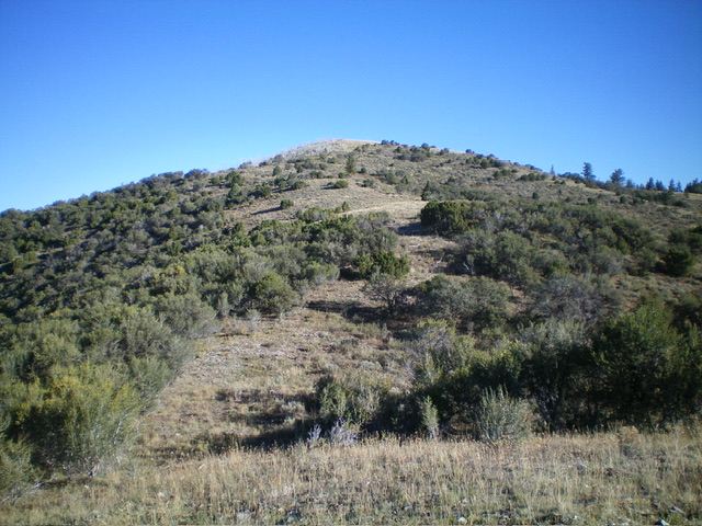
The summit hump of Peak 7241 as viewed from the high ridgeline to its south. Livingston Douglas Photo

The fence-row summit of Peak 7241 with its newly-built summit cairn. Paul Benchmark is in the distance. Livingston Douglas Photo
Additional Resources
Regions: Bannock Range->SOUTHERN IDAHO
Mountain Range: Bannock Range
Longitude: -112.4828 Latitude: 42.5251