Elevation: 9,347 ft
Prominence: 327

This peak is not in the book. Published December 2024
Peak 9347 and its neighbor to the northwest (Peak 9408) sit on a high ridgeline that separates Twelvemile Creek from Tenmile Creek in the Eastern Salmon River Mountains. It is most easily climbed from Yankee Fork Road to its southeast. Peak 9347 sees few visitors. USGS Elevenmile Creek
Access
From ID-75 at Sunbeam, drive north up [signed] Yankee Fork Road/FSR-070. At 8.3 miles, reach a signed junction with Loon Creek Road/FSR-172. Continue northeast on Yankee Fork Road. Reset your odometer at this junction. At 2.9 miles, reach the signed junction with Fourth of July Creek Road/FSR-073. At 3.2 miles, reach the Custer Campground (left). At 4.0 miles, reach the [signed] Fivemile Creek trailhead (FST-161).
At 4.6 miles, cross the to the west side of the Yankee Fork of the Salmon River on a bridge. At 4.9 miles, cross Greylock Creek on a bridge. At 7.9 miles, cross to the east side of the Yankee Fork of the Salmon River on a bridge. At 9.1 miles, cross to the north side of the Yankee Fork of the Salmon River on a bridge. At 10.9 miles, park at a pullout/campsite along Yankee Fork Road just south of the bridge crossing of Twelvemile Creek. This pullout is at 7,345 feet and 44⁰28’34”N, 114⁰33’56”W).
This is the first leg of a 3-peak adventure that includes Peak 9347, Peak 9408, and Peak 9539. It covers 10.5 miles with 4,475 feet of elevation gain round trip.
Southeast Ridge, Class 2+
The Climb
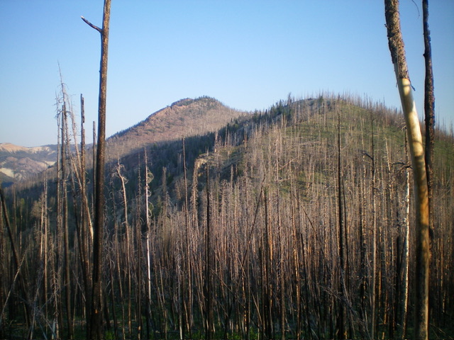
From the roadside pullout/campsite, scramble west up a steep slope of gravel, scrub, and blowdown to reach a ridge crest. Head right/north on the ridge to a juncture with the southeast ridge of Peak 9347 at just above 7,600 feet. Scramble west-northwest up the ridge in a charred pine forest. This burn area has a fair amount of downed timber, some new growth pines sprouting up, and some areas of loose underlying scree/gravel. Skirt the north side of Point 8417 and descend northwest 70 vertical feet to a saddle of heavy blowdown.
From the saddle, continue northwest up through more burnt forest (with a more modest amount of blowdown). Climb up over another ridge point/hump (8720+) and drop 60 vertical feet to another ridge saddle. From this saddle, scramble northwest up over Point 8912 then descend 75 vertical feet to a final saddle. From this saddle, climb west up a steep slope of downed timber and loose scree/gravel to reach the rocky, ridgeline summit of Peak 9347 (Class 2+). The high point is either an open ridgeline (where I built a summit cairn) or two rocky outcrops just preceding it. Stand atop all three spots “just to be sure.” There were no signs of previous ascent.

Looking up the burnt southeast ridge. The summit hump is just left of center. Point 8912 is the hump right of center. This was my ascent route. Livingston Douglas Photo
Northwest Ridge, Class 3
The Descent (then Ascent)
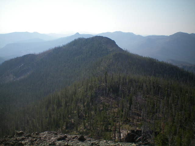
From the summit, descend a surprisingly steep, loose, and difficult Class 3 mix of ridge rock, minor gravel chutes, live pines, and loose scree to reach gentler slopes below in a live pine forest. Reach a ridge saddle at 9,020 feet (Saddle #1). From Saddle #1, climb over a rocky ridge point or do a torturous traverse around the ridge point on angled gravel in a pine forest with lots of blowdown. I did both and recommend the “climb over” option. Once past this ugly, rocky ridge hump (with cliffs on its north and northeast sides), reach another ridge saddle at 9,020 feet (Saddle #2). Let’s call this the connecting saddle with Peak 9408. This concludes the first leg of today’s 3-peak journey. Peak 9408 is up next.

Peak 9347 (dead center) as viewed from Peak 9408 to its northwest. The northwest ridge is in dead center. Livingston Douglas Photo
Additional Resources
Regions: Eastern Salmon River Mountains->Salmon River Mountains->Southeast Corner Peaks->WESTERN IDAHO
Mountain Range: Eastern Salmon River Mountains
First Ascent Information:
- Other First Ascent: Northwest Ridge--Descent and Ascent
- Year: 2024
- Season: Summer
- Party: Livingston Douglas
Longitude: -114.6043 Latitude: 44.4869
