Elevation: 9,515 ft
Prominence: 535

This peak is not in the book. Published December 2024
Peak 9515 is the high point on a rugged ridge that separates Tenmile Creek from Eightmile Creek in the Eastern Salmon River Mountains. It is seldom climbed. Peak 9515 is most easily climbed from Yankee Fork Road to its southeast. USGS Elevenmile Creek
Access
From ID-75 at Sunbeam, drive north up [signed] Yankee Fork Road/FSR-070. At 8.3 miles, reach a signed junction with Loon Creek Road/FSR-172. Continue northeast on Yankee Fork Road. Reset your odometer at this junction. At 2.9 miles, reach the signed junction with Fourth of July Creek Road/FSR-073. At 3.2 miles, reach the Custer Campground (left). At 4.0 miles, reach the [signed] Fivemile Creek trailhead (FST-161).
At 4.6 miles, cross the to the west side of the Yankee Fork of the Salmon River on a bridge. At 4.9 miles, cross Greylock Creek on a bridge. At 7.9 miles, cross to the east side of the Yankee Fork of the Salmon River on a bridge. At 9.1 miles, cross to the north side of the Yankee Fork of the Salmon River on a bridge. Park in a nice pullout/campsite on the east side of the road just past the bridge crossing (7,130 feet and 44⁰27’30”N, 114⁰35’23”W).
South Spur/East Ridge, Class 3
The Climb
The approach hike to the east ridge of Peak 9515 is an absolutely PUNISHING bushwhack. The initial section of the east ridge is also a tedious bushwhack. The final push up the steep rock of the east ridge is a JOY in comparison. So be advised. Perhaps the Tenmile Creek drainage is an easier bushwhack. It gives access to the steep, but climbable, east face of Peak 9515. Consider that route as a potential alternative.
From the parking pullout/campsite, cross to the west side of the road. Bushwhack west across an open, grassy marsh to reach a blowdown-strewn patch of pine forest. Once past that mess, reach open gravel terrain at the bottom of the east side of the south spur. Scramble northwest directly up the slope to reach the semi-open, forested ridge crest. Climb north then north-northeast to Point 8041 in reasonable forest. Point 8041 is in a burn area so there is a lot of charred forest and downed timber in this area. It is tedious.
From Point 8041, head north-northwest down a gradual slope of charred pine forest with endless downed trees (and new pines sprouting up amongst the charred deadfall). This section, and the lengthy, flattish saddle northwest of Point 8041, is brutal and slow. Once above the saddle, stay on the right/east side of the very rounded ridge and work through merciless blowdown and standing snags. By about 8,000 feet or so, there is a bit of open terrain on the right/east edge of the ridge. The ridge bends hard left/west at about 8,100 feet. You are now on the east ridge. The ridge crest has a lot of ridge pines and blowdown to work through.
At about 8,500 feet, the ridge gets rockier and narrower. Scramble through a series of rocky ridge outcrops with several minor ups and downs. Skirt the south side of the first rocky outcrop in Class 3 boulders and talus. The ridge pines and blowdown are less of a problem now. The ridge bends left/southwest at about 8,600 feet and is narrow and rocky. It then beds right-ish at 8,800 feet and is a mix of pines and rocky outcrops.
Continue west to reach the base of a massive reddish ridge buttress that is a landmark for this peak climb. There is a nice, white gravel/sand notch here. It is the launch point for both the upper east ridge or the east face. You can descend north for 100 vertical feet (ish) on easy rock and gravel to a basin underneath the ridge buttress to climb the east face from this notch. I descended the east face and returned to this notch to continue my descent. More on that later.
From the narrow notch, scramble west on angled, loose terrain (with pines mixed in) to pass three chutes heading right/north up to impossible dead ends (I climbed up the second chute and found this out). Continue west until you find a large gully that leads right/north to the summit area. Scramble up the right/east side of this gully to regain the crest of the east ridge above the massive buttress and some additional ridge towers above it. The east ridge is now heading northwest rather than west.
Skirt below several ridge towers to finally reach a climbable section of the east ridge. The scramble up onto the high east ridge is Class 3 work. Stay on the solid ledges of the ridge rock for much better footing than the steeply-angled, loose scree/gravel on the sides of the ridge. Once past the ridge outcrops, head northwest up the ridge crest in a mix of pines, gravel, and rocky ridge outcrops. A final ridge scramble leads north from the [lower] south summit hump to the Class 3 summit boulders and the airy summit perch. There were no signs of previous ascent. I built a modest cairn atop the highest boulder.

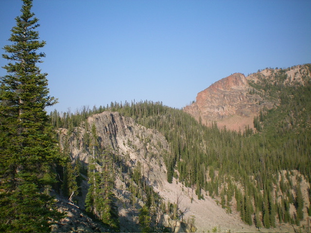
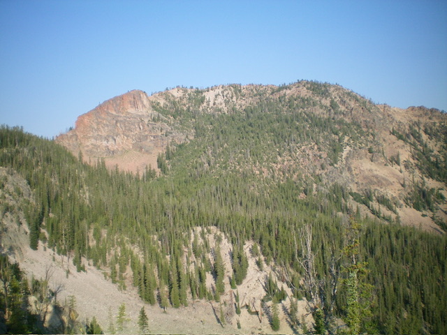
The upper east ridge (left of center) and the massive ridge buttress (right of center) that must be circumvented. The summit is on the high ridgeline at far right but is not yet in view. Livingston Douglas Photo
East Face/Southeast Shoulder, Class 3
The Descent
From the summit, head south along the ridge crest to the saddle between the north/true summit and the lower south summit. This saddle sits at the head of a gully that descends the east face. Leave the ridge at this saddle and descend the steep gully. Downclimb chutes of loose scree/gravel, face rock, and ribs in a pine forest. This is Class 3 work. Descend east then southeast to a small basin that sits underneath the massive red buttress on the east ridge. Skirt the base of the massive buttress on its left/east side in a mix of grass and loose scree/gravel on a steeply-angled slope.
Finish the traverse to the critical ridge notch in a white rock gully that leads from the small basin up to the ridge notch that sits on the east ridge at the base of the massive red buttress. The white rock gully is solid ground rock and goes quickly. There is a final patch of steep gravel/sand to reach the critical ridge notch. From the notch on the east ridge, scramble east along the tedious, rock-and-pines ridge crest briefly. Leave the ridge to bushwhack southeast down a forested shoulder that leads down to a dried-up pond (see USGS topo map).
This thickly forested shoulder is quite rounded high up and is difficult to find. But it gains definition as you descend. The shoulder is a punishing mix of thick pines and relentless blowdown. By 8,400 feet, the ridge is well defined. The left/northeast edge of the ridge provides some relief from the dense forest and copious blowdown. Lower down (below 8,000 feet), the ridge loses all definition and becomes a face. It steepens as it drops from 7,800 feet down to a partially dried-up pond with lots of green vegetation surrounding it.
This pond area is large and is mostly sand and gravel. It sits at the base of the southeast shoulder, just below 7,600 feet. Now the task is to traverse across two major gullies to return to the pullout along Yankee Fork Road at the bridge crossing. And it won’t be easy. Walk around to the south end of the wet marsh/pond and head east to the dry outlet stream drainage. Bushwhack briefly down this dry drainage through thick pine forest with heavy blowdown. Cross Gully #1 and climb 30 vertical feet to contour east across the south side of Point 7686. Contour on angled, forested terrain (not too bad) to reach open scree/gravel.
Find a helpful game trail that descends diagonally to cross a wet stream drainage (Gully #2). Jump across the small stream and continue on a game trail that heads diagonally northeast up onto the south spur of the east ridge (the lowest section of the ascent route). Contour northeast across the shoulder then turn right/southeast to descend to the road once you have reached the north side of the Yankee Fork of the Salmon River. Bushwhack through the blowdown-strewn patch of young pines and across the grassy marsh to reach Yankee Fork Road and the nearby pullout/campsite.
Additional Resources
Regions: Eastern Salmon River Mountains->Salmon River Mountains->Southeast Corner Peaks->WESTERN IDAHO
Mountain Range: Eastern Salmon River Mountains
First Ascent Information:
- Other First Ascent: South Spur/East Ridge
- Year: 2024
- Season: Summer
- Party: Livingston Douglas
- Other First Ascent: East Face/Southeast Shoulder
- Year: 2024
- Season: Summer
- Party: Livingston Douglas
Longitude: -114.6231 Latitude: 44.4723

