Elevation: 9,965 ft
Prominence: 349
This peak is not in the book. The map elevation is 9,961 feet. Published November 2024
Peak 9965 is one of several foothills on the southwest side of the Lost River Range. It is a ranked bump on the northwest ridge of Mount McCaleb (11,679 feet). Peak 9965 is most easily climbed from a gully on its south side. Most aspects of this mountain have cliff bands and rock towers/blocks that are difficult to surpass. USGS Leatherman Peak
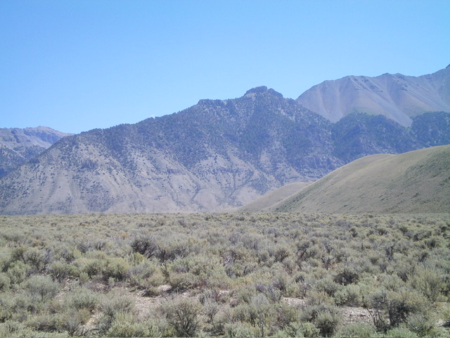
Peak 9965 (in mid-ground) as viewed from the southwest. The summit is right of center and the long west ridge is the skyline. Livingston Douglas Photo
Access
Upper Cedar Creek Road/FSR-127 [(B)(12) on Page 292 of the Book]. Please note that Upper Cedar Creek Road is currently blocked by posted, gated private land. But there is a workaround to get to the mouth of Upper Cedar Creek. The workaround requires a 4WD vehicle with high clearance. Read on.
From US-93 exactly 5.5 miles northwest of Mackay (at MM115), turn right/northeast onto [signed] Upper Cedar Creek Road. Drive 1.1 miles to the gated, posted road closure. From the gated closure, go left/west on an unsigned 2-track road that follows the left/south side of a fence row and soon crosses another cattle fence (wire gate) and bears left/west at an unsigned junction soon after the fence crossing.
The 2-track road bends left-ish/southwest and descends to a “T” junction with a north-south BLM road that comes up from US-93 at virtual MM115.9. Reset your odometer at this “T” junction. This junction is 0.6 miles from the road closure gate on Upper Cedar Creek Road. At 1.8 miles, go right/east at an unsigned “T” junction. At 2.5 miles, go straight/east at an unsigned 4-way junction. Merge onto Upper Cedar Creek Road here, just above where it fords the canal/aqueduct. At 2.7 miles, reach a cattle gate/fence. Park here (7,095 feet and 44⁰00’25”N, 113⁰39’55”W) or drive another 0.1-0.2 miles up the road to its end at the mouth of Upper Cedar Creek.
There is a more direct way to reach the lower ramparts of Peak 9965. From the bottom of the Mackay Dam on US-93, drive northeast then north up a BLM road that follows the east side of Upper Cedar Creek. Look for an unmapped 2-track that heads up to the mouth of the south gully. While the 2-track road up the east side of Upper Cedar Creek crosses private land, I saw a pickup truck parked at the top of the road at the mouth of Upper Cedar Creek on the east side of the canyon. Consequently, public access may be allowed on this BLM road and the road appears to be drivable.
Map Errors
Maps fail to show all of the 2-track roads in this area, including the workaround road to reach the mouth of Upper Cedar Creek and the 2-track road that heads up a shoulder on the right/south side of the south gully of Peak 9965.
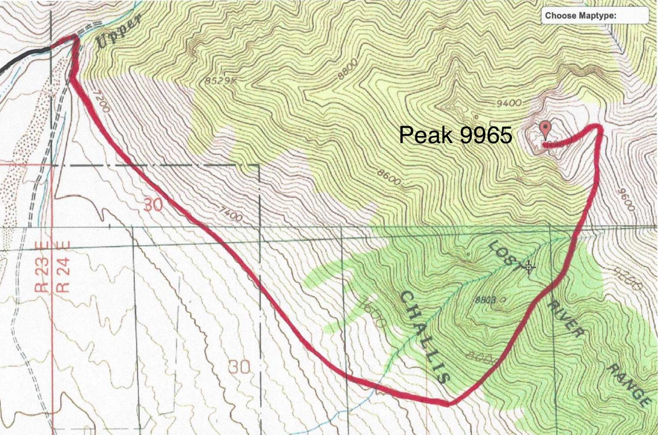
South Gully/Northeast Face, Class 2
The Climb
From the wire gate (7,095 feet), cross to the east side of the cattle fence and hike northeast down to the road’s end and a crossing of the canal/aqueduct on a wooden plank. Once across the canal, follow a cattle fence right/south on a berm on the east side of the canal and look for a reasonable way to bushwhack down and across Upper Cedar Creek to your left/east. Cross Upper Cedar Creek on a log (7,025 feet) and follow a cattle trail briefly east up onto the 2-track road on the east side of the mouth of the canyon.
Follow the road right/south for about 0.2 miles to reach a well-beaten cattle trail that angles diagonally left/southeast to climb up onto a grassy bench. Once atop the bench, follow a fence row southeast for a short distance then leave it to bushwhack diagonally left/east-southeast up the slope of grass/scrub at the base of the mountains. There are several dry gullies and shoulders to cross as well as some scattered mountain mahogany in this upward face traverse. Contour as low as possible for the first 1-1/2 miles or so. The terrain is easier and less angled lower down.
As you approach the south gully, angle diagonally left/upward to 7,600 feet to find an unmapped 2-track on a shoulder that sits on the right/east side of the south gully. This is the first gully with a 2-track road heading up (or near) it. That, in itself, is helpful in finding the correct gully to climb amongst several gullies in this area [if you pick the correct gully, you need not climb this shoulder in the first place—just bushwhack up the gully]. From the shoulder, head northwest and drop slightly into the south gully.
Contrary to another climber’s report, the south gully is not a “rocky draw heading north.” Instead, it is a dry creek bed with lots of brush and junipers/pines with some loose underlying scree. It heads northeast (not north) and bends north-northeast higher up. The dry creek drainage in the south gully is best climbed in its center, not its steeply-angled, loose sides. The gully becomes rockier higher up, but the brush and pines don’t end until you are almost at the head of the gully on a shoulder/ridge.
This gully bushwhack is tedious, thick, loose, and steep-ish. Once at tree line, there is a massive, loose, steep scree slope dead ahead. Skirt its left/northwest side and stay in scrub with scattered pines to reach the head of the gully (Gully #1) on a shoulder. From this shoulder, head left-ish/north across a massive scree slope on a game trail to reach a smaller, narrower gully (Gully #2). Gully #2 heads north to the ridge crest. Gully #2 is somewhat rocky, but is easy and open. It has little brush and no trees.
Climb the center of it to quickly reach the ridge crest at a grassy saddle after scrambling up a final patch of scree/gravel. From the saddle, head left/west up easy, broken scree. Scramble left-ish/southwest up a ridge (of sorts) of easy rocky outcrops with a scree base. Finish off this peak by heading right/west up through a few rocky ridge outcrops to reach the cairned high point of Peak 9965. The summit offers magnificent views of Mackay and Mackay Reservoir.
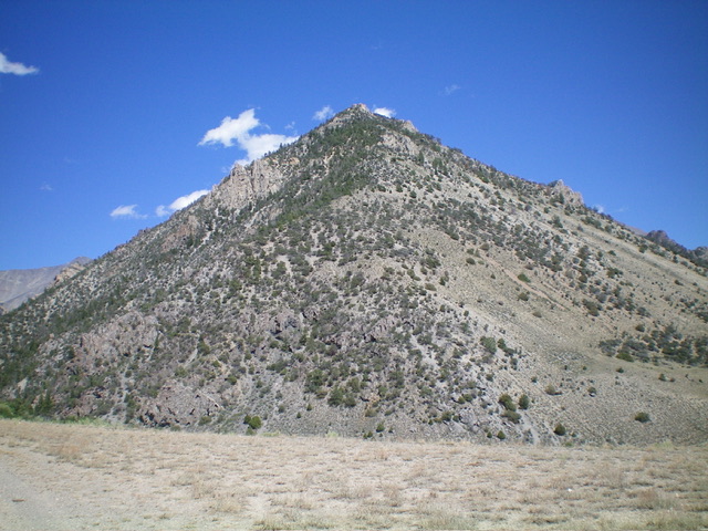
The west ridge of Peak 9965 (dead center, coming at the camera) as viewed from the mouth of Upper Cedar Creek Canyon. The summit hump is not visible from here. Livingston Douglas Photo
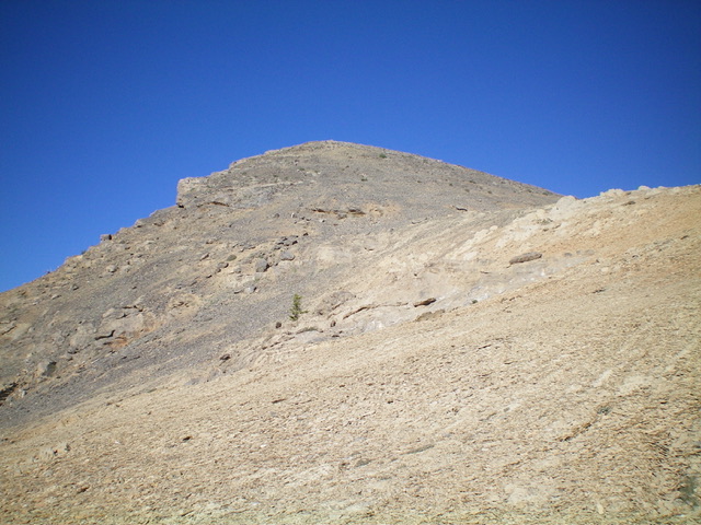
Peak 9965 as viewed from the base of the northeast ridge. This was the final leg of my ascent route. Livingston Douglas Photo
Additional Resources
Regions: EASTERN IDAHO->Lost River Range
Mountain Range: Lost River Range
Longitude: -113.63281 Latitude: 44.00360
