Elevation: 9,167 ft
Prominence: 3,642
This peak is not in the book. Livingston Douglas added an alternative access route, new routes, and new photos. Updated November 2024
Sedgwick Peak sits above the headwaters of Cottonwood Creek, Densmore Creek, and Beaverdam Creek in the Portneuf Range. It is entirely on State of Idaho land. Sedgwick Peak gets no respect in Idaho’s mountain universe. Despite its rugged nature and its expansive forest cover, it was overlooked by Teddy Roosevelt and Gifford Pinchot when they made numerous last-minute designations of National Forests under the President’s soon-to-expire authority. As a result, the portion of the Portneuf Range south of Lava Hot Springs, Idaho ended up as State of Idaho and private land. USGS Sedgwick Peak
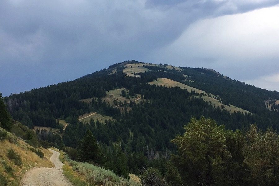
Sedgwick Peak as viewed from the west side of Bald Mountain.
Sedgwick Peak is a big, towering peak with a massive summit and 3,642 feet of prominence. The southern end of the summit plateau is the home of half a dozen communication facilities. The views from the top are vast and speak volumes about the interesting topography south of Pocatello.
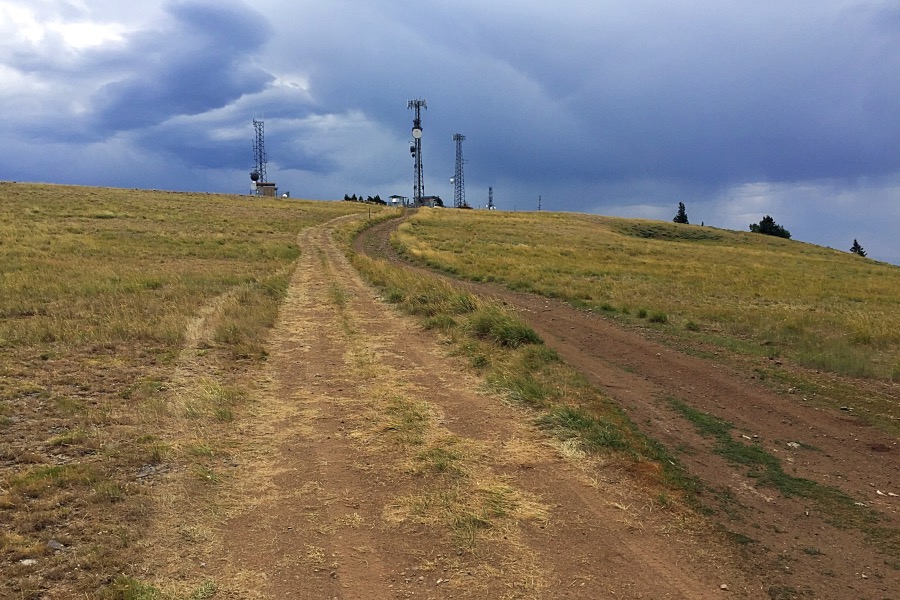
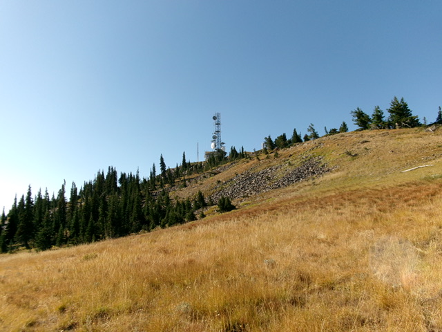
Nearing the top of the summit plateau.
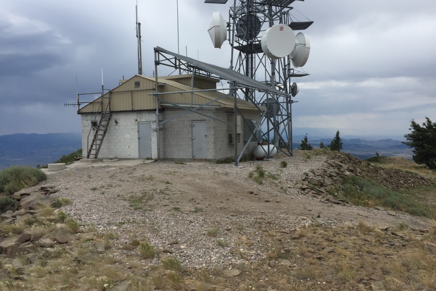
The summit of Sedgwick Peak.
Access and Route, Class 1
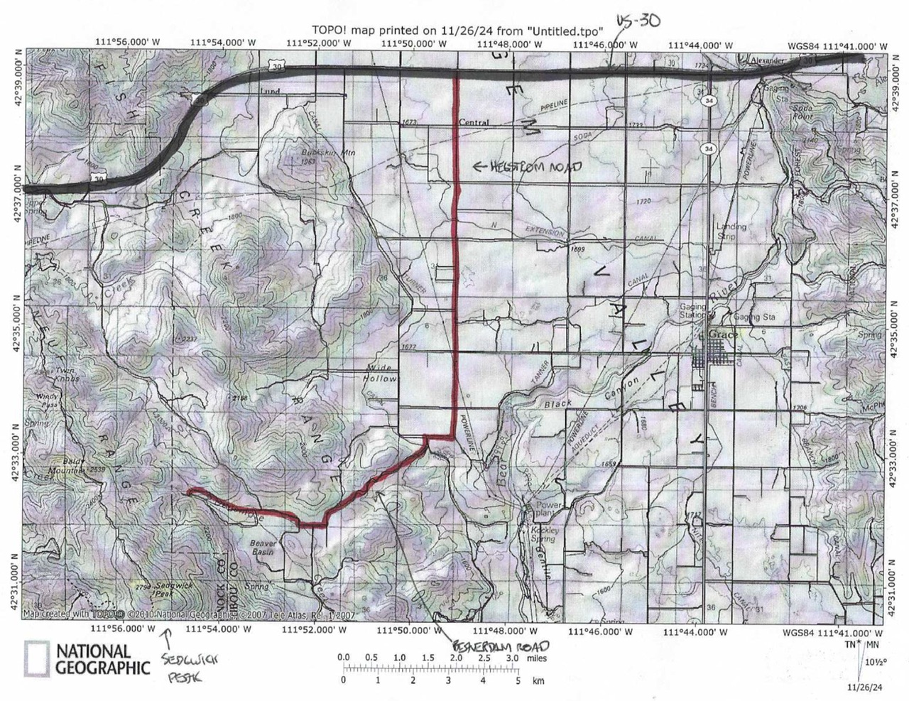
Because much of the area surrounding this peak is private property, access is an issue. The only access I know of starts in Lava Hot Springs. From Main Street and Center Streets in Lava Hot Springs, drive west on Main Street to 4th Avenue West and turn left/south. Follow this paved road to the Lava Hot Springs Cemetery, which will be on your left. Turn left on the dirt road just before the Cemetery. You are now on a legitimate 4WD road that leads to Sedgwick’s summit in 9.5 miles.
In roughly 2.0 miles, you will come to subdivision of sorts which includes houses, trailers and a good section of road. This road is named the Thunder Mountain Road. It is a private road that leads from the valley to the development. Clearly, the Thunder Mountain Road would be the best way to reach this spot but there is no public access at its base. Fortunately, there is an easement to get you to your next turn, the signed Wyoming Trail Road. Turn left and continue on this narrow, steep, winding road to the summit.
Use the Ken Jones link below for a GPS track using this route.
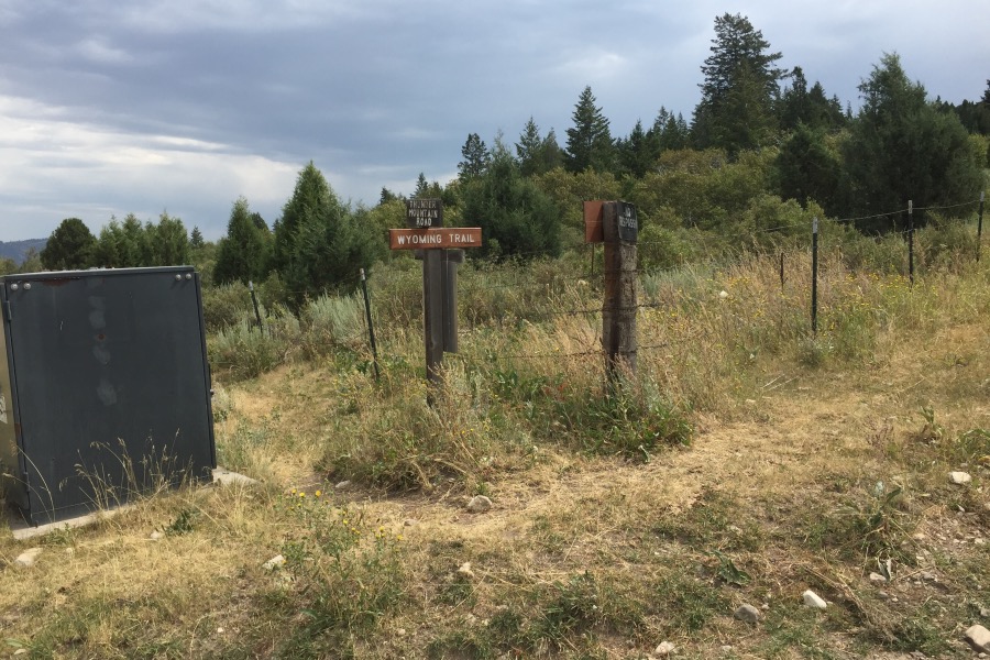
The Thunder Mountain Road/Wyoming Road junction.
Northwest Ridge and Northeast Face by Livingston Douglas
The antenna-clad summit of Sedgwick Peak as viewed from high on the northeast face. Livingston Douglas Photo
Access
I believe the peak is best climbed from Beaverdam Road to its northeast rather than the access route above. Although there the service road to its communication-tower-clad summit is passable, it is also rugged and may not be accessible to the public because this area is a mix of private and public land. This climb is entire climb is in public land. This access route requires a 4WD vehicle but not high clearance. It is a better route for most hikers who lack a 4WD high-clearance vehicle to approach the summit via the Lopez route.
This access route has no issues with private landowners. From US-30 at virtual MM381.9, turn south onto [signed] Hegstrom Road. Follow this well-maintained county road for 6.5 miles south to a sharp right/west bend. After another 0.5 miles, reach a signed junction with Gentile Valley Road. Turn left/south onto Gentile Valley Road and follow it for 0.1 miles to a signed junction with Beaver Dam Road.
Turn right onto Beaver Dam Road and reset your odometer. At 2.0 miles, reach a crest in the road. At 3.0 miles, turn right at an unsigned “T” junction. At 3.8 miles, reach an unsigned junction with Fish Creek Road. Continue west on Beaver Dam Road. At 4.3 miles, go right at a signed junction with Earls Way (left). At 12.2 miles, reach a pullout area with a large cattle cistern nearby. The road becomes a steep, badly-rutted ATV trail after this point. Park here (6,735 feet and 42⁰32’22”N, 111⁰54’42”W). The final ½ mile of Beaver Dam Road has some rutting issues. Drive a 4WD vehicle with good tires and medium clearance for this section of the road.
Sedgwick Peak Access
Map Errors
Maps fail to show a decent jeep road that is on the northeast face of the ridge between Baldy Mountain and Sedgwick Peak. This jeep road intersects the ATV trail heading west up toward Baldy Mountain. This junction is at about 6,950 feet and is only about 1/8 mile west (and up from) an initial unsigned road junction at a side gully that heads north. The USGS topo map shows an old jeep trail heading southwest then south up Densmore Creek and then up onto a shoulder on the east side of the creek drainage. That road no longer exists nor are there any remnants of it.
Northwest Ridge, Class 1
The Climb
From the low point on the ridge road just below (and southwest of) the 7,900-foot connecting saddle with Baldy Mountain (8,327 feet), follow the meandering, rocky 2-track jeep road as it heads south then southeast to the antenna-clad summit of Sedgwick Peak. This rugged road seems to go on forever. The antenna-clad summit area is extensive. The high point lies at the southeast end of the lengthy stretch of communication towers. The high point is on the [obvious] highest hill on the summit ridge. There is a communication tower and building here as well as a USGS benchmark in a ground boulder on the talus heap that is the high point. The benchmark is about 10 feet away from the high point on the talus heap. There is no summit cairn.
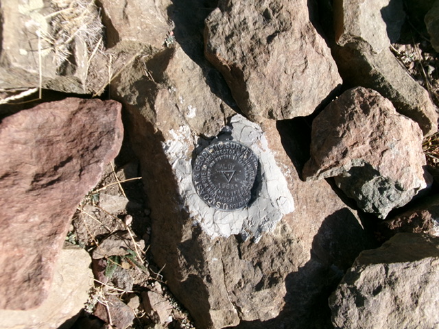
The USGS benchmark (“Baldy”) atop Sedgwick Peak. Livingston Douglas Photo
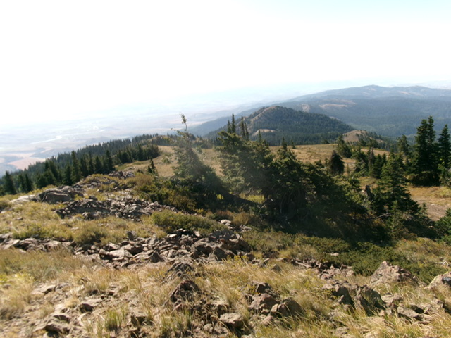
Summit view from atop Sedgwick Peak, looking southeast. Livingston Douglas Photo
Northeast Face, Class 2
The Descent
From the summit, head north then northeast down an open, grassy slope to soon reach the pine forest. Angle left-ish/north to try and find the Densmore Creek drainage, which heads north directly back to the parking area and cattle cistern where today’s 2-peak climb began. The pine forest is thick with pines, brush, and deadfall. It is a face that eventually becomes an elusive shoulder. In some areas, the forest goes quickly but, in other areas, it is a tedious bushwhack with copious deadfall.
The sides of the shoulder are littered with deadfall and the ridge itself becomes impossibly thick with brush and willows lower down. Surprisingly, the Densmore Creek drainage itself works better in this area. Just keep heading north. Stumble on a good jeep road that crosses the face. This road is not shown on maps. Follow the road left/northwest as it works its way around several shoulders and dry gullies. The road bends right/north (sometimes northeast) then left/northwest in a final drop to reach the second unsigned junction on the ATV trail of the ascent route for Baldy Mountain. Go right/east onto the ATV trail and follow it for about 0.4 miles down to the parking pullout and cattle cistern.
Additional Resources
Regions: Portneuf Range->SOUTHERN IDAHO
Mountain Range: Portneuf Range
Year Climbed: 2016
Longitude: -111.92376 Latitude: 42.51534