Garfield Mountain by Livingston Douglas

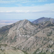
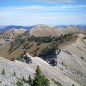
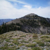
Climbing and access information for this peak is on Page 255 in the book. Published November 2022 Garfield Mountain is a rocky hump that is located on a summit massif that is dominated by [slightly-higher] Bell Rock (8,700 feet). It is most easily reached from the Mormon Hill trailhead by an unofficial use trail that is not shown on maps. … Continue reading

Bell Rock by Livingston Douglas

This peak is mentioned in the book on Page 255. Published November 2022 Bell Rock is a magnificent, intimidating rocky outcrop that is Class 5 in almost all directions. It has only one weakness: its southeast face which goes at Class 3. Bell Rock is the high point of the Garfield Mountain massif. USGS Muldoon Access Same as for Garfield … Continue reading

Peak 6641 by Livingston Douglas

This peak is not in the book. Published November 2022 Peak 6641 is the high point of a ridgeline that sits above the north side of Salix Creek in the Soldier Mountains. It separates Hawk Gulch from Salix Creek. Peak 6641 is most easily reached from Salix Creek Road which is a weak, 2-track affair best suited for ATVs. USGS … Continue reading

Peak 6700 by Livingston Douglas

This peak is not in the book. Published November 2020 Peak 6700 is located due west of Chimney Benchmark (7,162 feet). It sits above Salix Creek and has an intimidating southwest face. It is seldom climbed. This is the first leg of a 3-peak adventure that includes Peak 6700, Chimney Benchmark, and Peak 6641. This summit is located on State … Continue reading

Chimney Benchmark by Livingston Douglas

This peak is not in the book. For a winter ascent of this peak, use the three trip reports linked below. Published November 2022 Chimney Benchmark is a big mountain that separates Chimney Creek from Cow Creek in the Soldier Mountains. It has some old 2-track roads that will get you close to the summit area. The summit is located … Continue reading

White Butte by Livingston Douglas

This butte is not in the book. Published November 2022 White Butte is located due south of Walters Butte. The butte is located on posted, private land that is closed to the public. USGS Walters Butte Access White Butte is located southeast of Walters Ferry, ID. Turn right/east off ID-45 onto Walters Ferry Road and drive east to its [signed] … Continue reading