Peak 6758 by Livingston Douglas

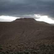
This peak is not in the book. Published November 2021 Peak 6758 is the high point of a complex of hills that sit directly above Challis on its northwest side. Nearby Challis Benchmark (6,730 feet) is slightly lower. Due to the preponderance of private property in this area, it is a difficult peak to reach. This entire hike is on … Continue reading

Peak 6420 by Livingston Douglas

This peak is not in the book. Published November 2021 Peak 6420 is a hill that towers over Mill Creek, northwest of Challis. Given the preponderance of private property in this area, the only public access is from Mill Creek Road. Even so, you must avoid a private ranch along Mill Creek. Consult a land management map to stay legal. … Continue reading

Peak 8940 by Livingston Douglas

This peak is not in the book. Published November 2021 Peak 8940 is located due west of Mosquito Flat Reservoir. It has a steep east face and is seldom, if ever, climbed. Peak 8940 has a lengthy, forested summit plateau. USGS Twin Peaks Access From US-93 at the north end of Challis, turn left/west onto [signed] Clinic Avenue. Follow Clinic … Continue reading

Peak 7460 by Livingston Douglas

This peak is not in the book. Published November 2021 Peak 7460 is the high point on a long ridge line that runs up the east side of Pats Creek. The easiest ascent route comes up from Pats Creek Road/FSR-173 to the west. The south rib makes for a magnificent alternative to the mostly-road hike from the west and returns … Continue reading

Peak 6660 by Livingston Douglas

This peak is not in the book. Published November 2021 Peak 6660 towers over Eddy Creek to its west and Challis Creek to its south. There is a LOT of private land in this area, so be careful. Consult a land management map before undertaking this climb. This route is entirely on BLM land. USGS Pats Creek Access From US-93 … Continue reading

Peak 9338 by Livingston Douglas

This peak is not in the book. Published November 2021 Peak 9338 sits above, and southeast of, Buster Lake. The easiest ascent route is from Buster Lake and the northwest face and west ridge. Peak 9338 has very rugged north and east aspects. USGS Bayhorse Lake Access From the junction of US-93 and Main Street in Challis, drive west on … Continue reading