Peak 8796 (Dogslide Peak)

Peak 8796 (Dogslide Peak). John Platt Photo

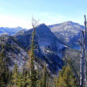
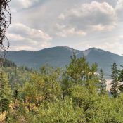
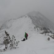
This peak is not in the book. Published February 2020 Peak 8796 is located due south of the Twentymile Lakes Basin and just southwest of Peak 8808. USGS Box Lake Access FST-085/FST-315, Twentymile Lakes Trail [(B)(2)(a) on Page 135]. North Gully, Class 2 Follow the trail to South Lake. Climb the gully to the summit ridge. Follow the summit ridge … Continue reading

Peak 8598 (Enos Envy)

This peak is not in the book. Published February 2020 Peak 8598 is a remote peak located east of Enos Lake and Enos Peak. It sits due south of Jungle Lake. USGS Enos Lake Access Take the FH-48/Lick Creek Road north from McCall to the Duck Lake trailhead. The trailhead is located just north of Lick Creek Summit [(B)(3) on … Continue reading

Peak 8802 (Enos Peak)

Enos Peak. John Platt Photo

This peak is not in the book. Published February 2020 This peak is located due south of Enos Lake and east of South Loon Mountain. USGS Enos Lake Access Take Lick Creek Road/FH-48 north from McCall to the Duck Lake trailhead. The trailhead is located just north of Lick Creek Summit [(B)(3) on Page 136]. The route from the Duck … Continue reading

Andys Hump

This peak is not in the book. Published February 2020 This peak is located on Coolwater Ridge, west of Coolwater Mountain. It is named after Andy Hjort, a government trapper and a deputy game warden in the early 1900s. He worked traplines in the area that became the Selway-Bitterroot Wilderness. Hjort also stocked many of the wilderness lakes with fish … Continue reading

Tiger Peak

This peak is not in the book. Daniel Coulter and Terri Rowe provided the updated information set out below. During their 2021 climb access to the peak was open. Updated August 2021 Tiger Peak is the highest point in the Coeur D’Alene Mountains. It is located south of Sunset Peak. This peak is located on private property and public access … Continue reading

Dry Ridge

Dry Ridge is another major ridgeline of the Peale Mountains. It is located east of Georgetown, Idaho.  It is bounded on the west by Dry Valley and Schmid Ridge and on the east by Freeman Ridge. There are 9 ranked summits crowning the ridge. Hawks Peak (9,979 feet) is the highest point on the ridge. Dry Ridge (8,975 feet) is … Continue reading