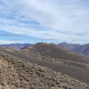
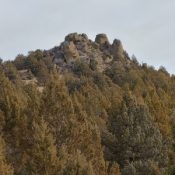
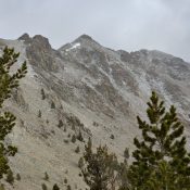
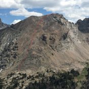
Della Mountain by Livingston Douglas

This peak is not in the book. Livingston Douglas’ narrative covers the traverse from Peak 6725. I have added a map, photo, and alternative route information. Updated November 2021 Della Mountain is an antenna-clad peak that towers over nearby Hailey, ID. It sits above Croy Creek, the Wood River, and Colorado Gulch. Its east face is intimidatingly steep. The easiest … Continue reading

Peak 6537 by Brett Sergenian

Peak 6537. Brett Sergenian Photo

This peak is not in the book. Peak 6537 is one of the more rugged Owyhee summits located in the Indian Meadows area east of South Mountain. USGS Indian Meadows Access To access Peak 6537, turn east from Mud Flat Road as if you were going to South Mountain. Pass the turnoff for South Mountain and follow the signs toward … Continue reading

Peak 10450 by Brett Sergenian

Peak 10450. Brett Sergenian Photo

Peak 10450 is located in the Boulder Mountains between South Glassford Peak and Peak 10446. USGS Ryan Peak Access From the North Fork of the Wood River trailhead [(A)(9)(a) on Pages 241-242], follow the North Fork Big Wood River Trail to the West Pass Trail. Follow West Pass Trail north for a couple of miles before turning west on the … Continue reading

Snowslide Point by Livingston Douglas

This named ridge point is not in the book. Published December 2019 Snowslide Point lies at the north end of a long ridge that Rick Baugher calls Snowslide Ridge. Ironically, the unranked point is officially named, but the high point (Peak 7882) is not. Since Snowslide Point is named AND is separated by almost a mile from Peak 7882, I … Continue reading

Shale Benchmark by Livingston Douglas

This benchmark is not in the book. Published December 2019 Shale Benchmark is the only point on Deadline Ridge with a USGS benchmark on it. It is located 1-1/2 miles south of Timber Butte and two miles north of the high point of Deadline Ridge. It is a handsome, rocky, rounded hump with beautiful views of Timber Butte, the ridgeline, … Continue reading