This peak is not in the book. Published December 2019 Peak 6145 is the southernmost ranked summit in the Pioneer Mountains. It is located northeast of Picabo, ID and is rarely visited. Peak 6145 has a lot of private land around it so be careful. Consult the BLM Fairfield map to stay out of trouble. It is a rather tedious … Continue reading
Search Results for: a cl
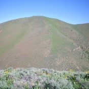
This peak is not in the book. Published December 2019 Peak 6492 sits at the head of Kent Canyon and towers over Croy Creek to the north. Its northwest face is quite steep. Much of this area is private land so be careful. Consult the BLM Fairfield map before venturing here and watch out for rattlesnakes and copperheads. The easiest … Continue reading
This peak is not in the book. Published December 2019 Red Devil Mountain is actually the lowest point on a ridge that separates Hangman Gulch from an unnamed gulch to the west. The summit offers a splendid view of Hailey, ID. This is a seldom-visited peak because it is clogged with thick sagebrush with loose scree underneath. Unlike its neighbor … Continue reading
This peak is not in the book. I updated this post with additional access information, a map, and a photo. Updated November 2021 Peak 6186 sits above Gilman Flat and is the largest of three peaks in the immediate vicinity that look northward to the lush, green ranch land of Gilman Flat. Beware of rattlesnakes and copperheads in this area. … Continue reading
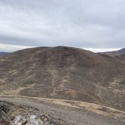
This peak is not in the book. Published December 2019 Peak 7422 towers 1,800 vertical feet above Greenhorn Gulch to the south. The southern half of the mountain is mostly BLM land whereas the northern half of the mountain is mostly on private land. Consult the BLM Sun Valley map to stay out of trouble. Greenhorn Gulch road is heavily … Continue reading
This peak is not in the book. I updated this post with additional access information and a map. Updated November 2021 Gilman Butte is a ranked summit that is located just east of Rocky Butte. It is a rocky outcrop, not a typical flat-topped butte. Gilman Butte is located on the south side of Croy Creek Road and Gilman Flat, due … Continue reading