Pike Mountain

Pike Mountain from Deadline Ridge.

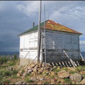
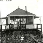
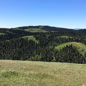
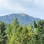
This peak is not in the book. Pike Mountain is located northeast of the Magic Mountain Ski Area. It is the highest point on the North Side of the South Hills. It was once the home of a fire lookout and, as one would expect, it a great place to survey the surrounding country. USGS Pike Mountain Access and Route, … Continue reading

Meadow Creek Lookout

The Meadow Creek Lookout in 2012. National Historic Lookout Registry Photo

This peak is not in the book. Meadow Creek Lookout is a remote peak. However, it is reached by a road because it is the location of a mothballed Forest Service fire lookout dating from the 1930s. The summit is approximately 8 miles southeast of Yellow Pine, but you will have to follow a circuitous route of nearly 25 miles … Continue reading

Rice Peak

Rice Peak in happier days. USFS Photo

Climbing and access information for this peak is on Page 117 of the book. See the access information below. Updated August 2020 Rice Peak is a former fire lookout site. The structure is still on the summit. Also see Boise National Forest Lookouts. USGS Rice Peak Updated Access FS-478 temporary closure (which started in 2014) is evidently still in place. … Continue reading

Monument Peak 8060

Monument Peak viewed from Trapper Mountain.

Climbing and access information for this peak is on Page 347 of the book. Livingston Douglas provided the updated access information found below. Updated November 2019 This Monument Peak is the highest point in Idaho’s South Hills. It is one of 12 Idaho peaks using word Monument in its name. It is a large, dome-shaped peak interspersed with forest groves … Continue reading

Thorn Creek Butte

Thorn Creek Butte viewed from Hoodoo Peak.

This peak is not in the book. Published June 2018 Thorn Creek Butte is located south of Idaho City. It has significant prominence and all of the nearby peaks and ridges are much lower in elevation. As a result, it has a massive 360-degree view. The peak can be accessed by roads from three directions. The best quality road is … Continue reading

Peak 7860

This peak is not in the book. Published June 2018 Peak 7860 sits due east of Green Mountain and southeast of McCall. USGS Blackmare Access Access the peak from the area of the Kennally Creek Campground [(B)(5) on Page 138]. Just before reaching the campground, turn onto FS-394. Follow FS-394 north until you reach the 6,400 foot contour. Park here. … Continue reading