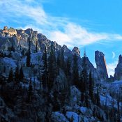
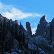
Davis Mountain

The summit cairn.

This peak is not in the book. Davis Mountain is the highest point in the central section of the Bennett Mountain Hills. The summit is accessed via the Davis Mountain Road. This rugged 4WD road passes just west of the summit. A spur road can be followed east to the electronic installation near the high point. USGS Davis Mountain Access … Continue reading

West Twin Peak

West Twin Peak viewed from the southwest along the East Fork Clover Creek.

This peak is not in the book. West Twin Peak is located due west of East Twin Peak on the Bennett Mountain Hills Crest. Like its twin, it can be climbed from almost any direction. USGS Fir Grove Mountain Access Road access to the peak’s south slopes is via the Davis Mountain Road. This road is discussed in detail on … Continue reading

Fir Grove Mountain

This peak is not in the book. Livingston Douglas provided the new route information found down the page. Updated November 2019 Fir Grove Mountain is located on the main Bennett Mountain Hills Crest between Peak 6491 and Peak 5875. USGS Fir Grove Mountain Access From its junction with ID-46, drive west on the City of Rocks Road. At 4.9 miles, … Continue reading

East Twin Peak

The summit cone of East Twin Peak. The 4WD road ends on the shoulder on the cone’s right side.

This peak is not in the book. East Twin Peak and its twin, West Twin Peak, are the most distinctive peaks on the Bennett Mountain Hills Crest. USGS Fir Grove Mountain Access This Peak is best accessed from Davis Mountain Road. This road runs from east to west on the south side of the Bennett Mountain Hills Crest between Gooding … Continue reading

Peak 5875

Peak 5875. viewed from the west.

This peak is not in the book. Peak 5875 is located west of ID-46 and south of Johnson Benchmark. It is a sagebrush- covered hill with nice views north to the Camas Prairie and the Soldier Mountains. USGS McHan Reservoir Access The Gooding City of Rocks Road crosses over the peak’s South Shoulder. Take ID-46 north from Gooding for 15 … Continue reading

Peak 6813 (Lone Tree Peak) by Brett Sergenian

This peak is not in the book. Published May 2018 “Lone Tree Peak” (Peak 6813) is located along the Idaho/Oregon border northwest of South Mountain and is accessed from Mud Flat Road. USGS Cliffs Access To access Peak 6813, turn onto Yturri Blvd south of Jordan Valley which turns into Mud Flat Road. Follow Mud Flat Road until you reach … Continue reading