Juniper Mountain by Brett Sergenian

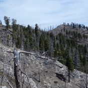
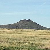
This peak is not in the book. A fire recently burned the summit area. The road is in surprisingly good condition. Updated May 2021 Juniper Mountain is located in the southern Owyhee Mountains about 45 miles southeast of Jordan Valley. Although only 6,820 feet in elevation, Juniper Mountain is large and has several unranked summits. Juniper Mountain is a drive … Continue reading

Peak 5985

This peak is not in the book. Published April 2018 Peak 5985 is located in the rugged, steep country rising above the West Side of the South Fork Salmon River. It is east of Teapot Mountain. John Platt and John Fadgen climbed the peak in early April 2018. John Platt’s trip report is linked below. USGS Fitsum Peak Access Access … Continue reading

Tims Peak

Tims Peak viewed from Dryden Peak.

This peak is not in the book. Tims Peak is an attractive cone-shaped mountain located north of Dryden Peak. It is located on private property and is not accessible without the owner’s permission. USGS Soldier Cap   … Continue reading

Dinosaur Ridge

The summit pinnacles.

This peak is not in the book. Livingston Douglas provided the new route information set out down the page. Updated December 2019 —————————————————————————— Dinosaur Ridge is located west of ID-75 and southeast of Magic Reservoir. This peak is named for the stegosaurus-like rock towers on its summit ridge. USGS Shoshone Ice Cave Access Access this peak from ID-75. Turn west … Continue reading

Timmerman Hills High Point

The highest point in the Timmerman Hills is this cone shaped point.

The Timmerman Hills are located on the North Edge of the Snake River Plain. ID-75 forms the West boundary of the hills and US-20 forms the North border. The plain forms the South boundary and the East boundary is the Picabo Hills. Picabo is pronounced “peek-a-boo.” This summit is the highest point of the Timmerman Hills. There are great views … Continue reading

Peak 5273

Livingston Douglas provided the new route information and additional photos found down the page. Updated December 2019 Peak 5273 is a rugged Snake River Plain butte that is located east of Wedge Butte and ID-75. The butte is capped by cliffs and spires. USGS Shoshone Ice Cave Access Peak 5273 is accessed from ID-75 where the Picabo Desert Road (a … Continue reading