This peak is not in the book. Peak 10677 is located northeast of North Twin and the main Lost River Range Crest. A number of climbers have scrambled over this peak on their way to North Twin. They have used FS-214 to approach the peak from the north. FS-214 is not in the book and I do not have any … Continue reading
Search Results for: a cl
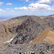
Climbing and access information for this peak is on Page 288 of the book. Updated November 2021 This peak is located southeast of Sunset Peak on the main Lost River Range Crest on a major northwest-southeast ridgeline at the south end of the Lost River Range. It has a magnificent, rugged west face and has only one feasible climbing route on … Continue reading
This peak is not in the book. The map elevation is 10,195 feet. LiDAR calculations place the elevation at 10,199 feet. The unofficial name was proposed by Rick Baugher. Derek Percoski climbed this peak in 2018 as part of loop that also included White Cap Peak. Livingston Douglas climbed the west face and descended the north ridge in 2024. Both … Continue reading
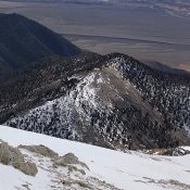
Climbing and access information for this peak is on Page 269 of the book. The route in the book utilizes the southeast gully to reach the summit. Livingston Douglas climbed a new route, the southeast face/southeast ridge. The last photo on the page shows the the entire peak. Updated November 2021 Peak 10420 is located east of the main Pahsimeroi … Continue reading
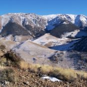
Climbing and access information for this peak is on Page 266 of the book. The book lists the elevation at 10,615 feet. LiDAR measurements have confirmed this elevation. Updated November 2024 This peak is the northwestern-most 10,000-foot summit in the Lost River Range. USGS Grouse Creek Mountain … Continue reading
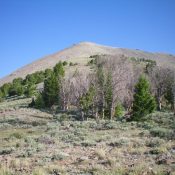
This peak is not in the book. Updated December 2019 Peak 10104 is a gentle hill due west of rugged Peak 11598/The Riddler. The easiest ascent route is the east ridge via the 9,780-foot connecting saddle with The Riddler. There is no road or trail to that saddle. This is a pretty remote area, no matter how you approach it. … Continue reading