Mount Sevy

This photo shows the south face of Mount Sevy. The summit block is on the left side of the high point.

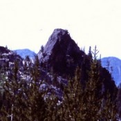
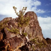
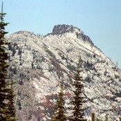
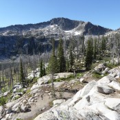
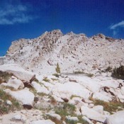
Climbing and access information for this peak is on Page 185 of the book. A variety of scrambling routes lead up the face to the summit block. Depending upon the route used to reach the hard granite on the peak’s upper slopes, you will have one to three pitches of moderate Class 5 climbing. I climbed this peak in 2000 … Continue reading

Devils Tooth

Climbing and access information for this formation is on Pages 96-98 of the book. Please note that the correct elevation is 7,820 feet, a bit higher than the figure in the book. Devils Tooth was first climbed in 1963 by Don Eastman and Jim Angell of the Mazamas. USGS He Devil … Continue reading

The Goblin

Climbing and access information for this peak is on Page 100 of the book. Please note that the current elevation estimate of 8,985 feet differs slightly from the book elevation. USGS He Devil … Continue reading

Selway Crags / Wounded Doe Ridge

The Selway Crags are found at the southern edge of the Selway-Bitterroot Wilderness Area. This rugged area is discussed in the book beginning on Page 64. This region contains the most extensively glaciated peaks in the central Clearwater Mountains. It is vertical country that is not crowded and is well worth a visit. Chimney Peak and Fenn Mountain are most … Continue reading

Rain Peak

Climbing and access information for this peak is on Page 113 of the book. Rain Peak is part of a long Lick Creek Range ridge that is anchored by Pearl Peak (Pearl triangulation station) in the north and Beaverdam Peak in the south. It is located west of Duck Lake and 1.0 mile north of Burnside Peak. USGS Box Lake … Continue reading

Big Peak

Climbing and access information for this peak is on Page 212 of the book. Big Peak is a remote Smoky Mountain summit which sets west of the Smoky Mountain crest. Use the links below for updated route information. USGS Baker Peak … Continue reading