
Climbing and access information for this peak is on Page 227 of the book. Peak 10041 is another nice summit found on the Horton Peak quadrangle. See the link below for a recent ascent. USGS Horton Peak … Continue reading
Climbing and access information for this peak is on Page 227 of the book. Peak 10041 is another nice summit found on the Horton Peak quadrangle. See the link below for a recent ascent. USGS Horton Peak … Continue reading
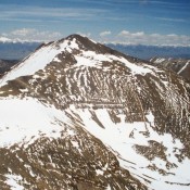
Climbing and access information for this peak is on Page 268 of the book. Pavlos is the 2nd-highest summit north of Doublespring Pass. It has been climbed from both the east and west. USGS Grouse Creek Mountain … Continue reading

Climbing and access information for this peak, formerly Gooseberry Peak, is on Page 267 of the book. Livingston Douglas provided the additional comments and photos and Brett Sergenian provided his GPS track that you will find below. Updated November 2021 Mount Darcy is a complicated summit located above Christian Gulch. I climbed it from Christian Gulch via the East Buttress/South … Continue reading
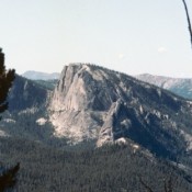
Climbing and access information for this peak is on Page 128 of the book. Livingston Douglas increased our knowledge of this magnificent peak by adding the South Ridge Route and new photos. Updated November 2023 This is one of two Idaho peaks named Sugar Loaf. With its 800-foot, near-vertical, granite East Face, this Sugar Loaf the more impressive of the … Continue reading
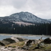
Climbing and access information for this peak is on Page 114 of the book. Updated January 2020 Buckhorn Mountain is located southeast of McCall and 2.0 miles due east of a popular hiking destination, Boulder Lake. See John Platt’s trip report linked below for details of his 2010 ascent. USGS Paddy Flat … Continue reading
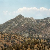
Climbing and access information for this peak is on Page 109 of the book. Patrick Butte sees few ascents because of its remote location. But due to it ranking as Idaho’s 32nd-most prominent peak (with 2,901 feet of prominence), it has gained in popularity recently. I have yet to make it to the top. John Platt and Art and Carol … Continue reading