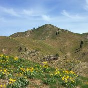
McGowan Peak

Climbing and access information for this peak is on Pages 267-268 of the book. The book lists the elevation at 10,716 feet. More recent estimates give the peak an elevation of 10,740 feet. McGowan Peak is a rarely-climbed summit in the Pahsimeroi section of the Lost River Range. The photo essay below documents my 1991 ascent. Use the trip report … Continue reading

Mount Cramer

The western face of Mount Cramer viewed from Cramer Pass.

Climbing and access information for this peak is on Page 199 of the book. One of the highest Sawtooth Range summits, Mount Cramer is usually climbed from the east. It has a nearly vertical West Face that towers over the Cramer Lake Basin. The eastern approach is not nearly as treacherous. USGS Mount Cramer … Continue reading

Iron Creek Point

Climbing and access information for this peak is on Page 304 of the book. This “Point” is a peak in every respect. It is a great hike via its deteriorating trail. In 1992, the trail to the abandoned lookout was in fair shape. We spotted sign of goats on the ridge south of the summit. Nearby Bear Mountain can be … Continue reading

Peak 10757 (Metaxy Peak) by Livingston Douglas

Climbing and access information for this peak is on Page 267 of the book. Updated November 2021 Metaxy Peak is located between Mount Darcy and Pahsimeroi Pyramid on the main Pahsimeroi Crest. USGS Grouse Creek Mountain Access This is the first leg of a 2-peak journey that includes Metaxy Peak and Pahsimeroi Pyramid (10,749 feet). It covers 7.5 miles with 3,650 … Continue reading